A Border Fortress in the Highlands of Canaan and a Proposed New Location for the Ai of Joshua 7–8.
Join the ABR team as we continue to excavate the remains of this important fortress and strong candidate for Joshua's Ai.
The Site
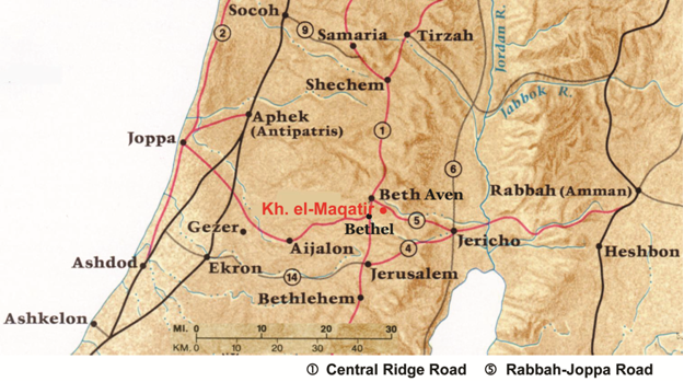
Khirbet el-Maqatir is strategically located in the highlands of Canaan, 15 km (9 mi.) north of Jerusalem (17378/14693), on the south bank of the Wadi el-Gayeh. It lies on the east side of the main north-south ridge road that goes through the central hill country, running from Jerusalem to Bethel (modern El Bireh)1 west of the site and on to Shechem to the north. A major east-west road proceeded from Rabbah in Transjordan, past the north side of Kh. el-Maqatir, then to Bethel and on to Joppa on the Mediterranean coast (Fig. 1). The site is situated on an eroded natural limestone hill whose summit is 890 m (2920 ft.) above sea level. Bedrock is exposed in many places, with the remaining soil less than 1 m (3.3 ft.) deep in most cases.
 © Associates for Biblical Research 2011
Fig. 1. The location of Kh. el-Maqatir in relation to the major roads in central Canaan in the second millennium BC.
Edward Robinson, Claude Conder, and Horatio Kitchener, as well as other early explorers who visited the site, made note of a Byzantine church on the summit and a Late Hellenistic/Early Roman building complex 200 m (220 yd.) to the southeast, some 10 m (33 ft.) below the summit. A number of cisterns are associated with these remains; no natural source of water has yet been located on the site. Kh. el-Maqatir was surveyed by the Archaeological Survey of the Hill Country of Benjamin in 1981. The participants in that survey were the first to report remains between the summit and the Late Hellenistic/Early Roman building complex, remains which they dated to the Middle Bronze and Iron Age I periods. The Late Hellenistic/Early Roman remains were labeled Site 17-14/36/1, and the Middle Bronze and Iron Age I remains Site 17-14/36/2 (Finkelstein and Magen 1993: 22*, 81–82; Finkelstein, Lederman, and Bunimovitz 1997: 519–22). The Byzantine monastery on the summit, however, was not surveyed. The site has suffered from extensive robbing, agriculture, erosion, and other disturbances from antiquity to the present, and is currently threatened by impending development.
History of Excavations
Salvage expeditions have been conducted from 1995–2000 and 2009–present, sponsored by the Associates for Biblical Research under the direction of the author. Five phases of occupation have been identified:
- Middle Bronze Age, ca. 1600–1500 BC, pottery only, southeast slope
- Late Bronze I, ca. 1500–1400 BC, ca. 1 ha (2.5 acres) fortress, southeast slope
- Iron Age I, ca. 1200–1100 BC, squatter occupation, southeast slope
- Late Hellenistic/Early Roman, ca. 100 BC–AD 100, small fortress and settlement, southeast slope
- Byzantine, ca. AD 375–525, monastery, summit
All builders at the site built directly on bedrock. Extant soil is the result of fill operations in antiquity and the accumulation of erosional material against surviving wall stubs. Fill stones from the walls of the fortresses, left behind when the larger stones were robbed out, blanket the site today.
History of the Site
Late Bronze I Fortress
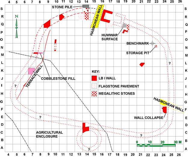
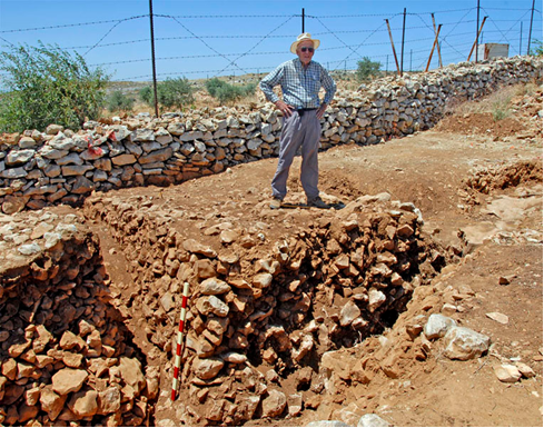
Remnants of a small fortress dating to the Late Bronze I period have been found on the southeast slope of the site, Archaeological Survey of the Hill Country of Benjamin Site 17-14/36/2. Although some parts of the fortress are inaccessible due to a fenced-off agricultural plot (Fig. 2), based on present evidence it appears to have occupied an area of ca. 1 ha (2.5 acres). In spite of its small size, the bastion was strongly fortified. The remaining foundations of the north and west walls are 4 m (13 ft.) wide (Fig. 3). The west half of a two-chamber gate was excavated on the north side of the fortress (Fig. 2). The east half was robbed out in antiquity, most likely by the builders of the Late Hellenistic fortification walls (see below). Two lower socket stones and one upper pivot stone were found in the gate passageway.
 Credit: Bryant G. Wood, © Associates for Biblical Research 2000
Fig. 2. Plan of the Late Bronze I fortress at Kh. el-Maqatir.
 Credit: Michael Luddeni, © Associates for Biblical Research 2009
Fig. 3. Segment of the western wall of the Late Bronze I fortress in Square M7, with a modern fenced-in agricultural plot visible in the background.
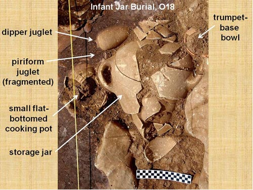
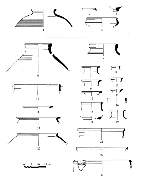
A number of poorly-preserved walls were found immediately inside the gate. In 2009 an infant jar burial was discovered in the northeast corner of Square O18, adjacent to one of these walls. The burial jar was 37 cm (15 in.) below the surface, resting on bedrock. The offering vessels, burial jar, and typology of the burial suggest a date at the beginning of the Late Bronze Age for the internment, ca. 1500 BC. The fortress was destroyed by a massive conflagration, as evidenced by severe burning in the form of reddened and fragmented bedrock in the gate passageway, burned and calcined building stones and calcined bedrock in the area of the gate, ash deposits in various places, and refired Late Bronze IB pottery throughout the fortress. The latest pottery associated with the fortress is LB IB in date, indicating a date of ca. 1400 BC for the fortress's destruction (Fig. 5).
 Credit: Michael Luddeni, © Associates for Biblical Research 2009
Fig. 4. Infant jar burial surrounded by offering vessels.
 © Associates for Biblical Research 2008
Fig. 5. Late Bronze Age I pottery from Square Q17, flagstone pavement inside gate: 1–4, Locus 10, surface of pavement; 5–23, Locus 12, clay bedding below pavement.2
A major focus of the excavation is to elucidate the geopolitical situation in the central hill country during the LB I period. The Wadi el-Gayeh has been identified as the border between the city-state of Jerusalem to the south and the city-state of Shechem to the north (Finkelstein and Na’aman 2005: 186). Situated on the south side of the Wadi el-Gayeh, close to an important crossroad, the LB I fortress can be understood as a northern border fortress protecting Jerusalem. A noteworthy feature of Kh. el-Maqatir is that there is line-of-sight communication between the site and Jerusalem. Thus, early warning could be provided to Jerusalem in the event of the approach of hostile forces from the north along the ridge road.3 Kh. el-Maqatir meets all of the geographic and archaeological requirements for Ai found in Joshua 7–8, and thus is a more viable candidate for the Ai of Joshua than the site of et-Tell located 1 km (0.6 mi.) east of Kh. el-Maqatir.4
Iron Age I Squatter Occupation
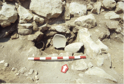
Iron Age I pottery from squatter occupation has been found dispersed throughout the area of the Late Bronze I fortress. It dates to the early part of the Iron Age I period, ca. 1200–1100 BC. The best preserved remains were found in Square Q9 where a poorly made domestic structure was built into the ruins of the Late Bronze I fortification wall. The structure, with one-stone wide walls, consists of several small rooms. The plan of one room measuring 1.5 x 2.0 m (4.9 x 6.5 ft.) is complete. In Square R11 a stone-lined pit ca. 0.7 x 1.0 m (2.3 x 3.6 ft.) was built into the corner of a similar structure (Fig. 6). In it were a restorable jug and rim sherds of several Iron Age I cooking pots, as well as a broken mortar and a damaged limestone roof roller 21 cm (8.3 in.) in diameter, 48.5 cm (1 ft. 7 in.) in length, and 32 kg (70 lb.) in weight (Fig. 6).
 Credit: Michael Luddeni, © Associates for Biblical Research 1999
Fig. 6. Iron Age I stone-lined pit in Square R11. On the left is a restorable jug, in the center a mortar, and on the right a roof roller. In the background is the ruined inner face of the north wall of the Late Bronze I fortress.
Late Hellenistic/Early Roman Fortress and Settlement
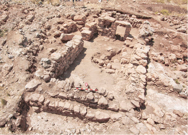
A building complex ca. 0.3 ha (0.75 acres) in size on the eastern side of the site, Archaeological Survey of the Hill Country of Benjamin Site 17-14/36/1, dates to the Late Hellenistic/Early Roman period. Fortification walls found to the west, north, and south of the complex indicate that a later fortress was built over the eastern half of the Late Bronze I fortress in the Late Hellenistic period. The northwest corner was excavated in Square X17. From there the western wall can be traced 48 m (160 ft.) south-southwest to Square Q15, passing just to the west of the west chamber of the Late Bronze I gate (Fig. 2). In Square X17 the wall is 4.0 m (13 ft.) wide at its base and in Square Q15 it is 5.0 m (16 ft.) wide. On the north the wall can be traced from Square X17 ca. 80 m (260 ft.) east-southeast to Square S29. In Square X17 the wall is 4.0 m (13 ft.) wide and appears to maintain that width to Square S29. In Squares S29 and S30 there is a northeast projection 3.5 m (11 ft.) wide and 4.5 m (15 ft.) long, apparently part of a gate, with a clear approach road leading to it from the northwest. No additional architecture from the gate has survived. A coin of Alexander Jannaeus (103–76 BC) from the north wall and coins of John Hyrcanus I (134–104 BC) and Alexander Jannaeus from the west wall suggest a date in the reign of Alexander Jannaeus for the construction of the fortress. Coins of Herod Agrippa I (AD 41/2), Porcius Festus (AD 59), and year 2 of the Great Jewish Revolt (AD 67/8) found during the 2011 season indicate that occupation continued into the first century AD. The Porcius Festus and Great Revolt coins were found in a well-preserved house (Fig. 7).
 Credit: Michael Luddeni, © Associates for Biblical Research 2011
Fig. 7. A well-preserved first-century AD house excavated during the 2011 season. Coins of Porcius Festus (AD 59) and year 2 of the Great Jewish Revolt (AD 67/8) were found in the house.
Byzantine Monastery
Systematic excavations of a church and coenobium5 monastery on the summit of the site were begun in 2010, under the direction of Area Supervisor Scott Stripling of Wharton County Junior College, Wharton TX. The church is of the classic basilica style with the central apse extending to the east (Fig. 8). The total length is 39.35 m (129 ft.) from the atrium entrance on the west to the east end of the central apse. Although the atrium has not yet been excavated, traces of all four of its walls are observable; they are ca. 0.90 m (3 ft.) wide. The nave is 6.0 m (20 ft.) wide and the aisles are 3 m (10 ft.) wide. An enclosed agricultural terrace likely ran the length of the structure on the north. The main entrance into the nave is 1.8 m (6 ft.) wide and has a threshold with sockets, likely for a double-winged door; it is flanked by two smaller entrances into the aisles, each 1.2 m (4 ft.) wide. Originally, the nave was separated from the aisles by columns with Corinthian capitals, as attested by early explorers. Four column shaft fragments are lying about on the surface. A. M. Schneider reported that two columns he observed in a schoolyard in El Bireh came from Kh. el-Maqatir (1934: 189–90). James Kelso stated that the Kh. el-Maqatir church had been plundered to furnish stone for the mosque in El Bireh (1958: 3–4; 1968: 8). Five of the original columns and a large foundation stone can be found in the fenced-in center of the traffic circle at the western approach to Deir Dibwan, 1.8 km (1.1 mi.) east-southeast of Kh. el-Maqatir. According to local residents, these were removed from Kh. el-Maqatir in 1990. The columns are 0.46 m (1.5 ft.) in diameter; the most intact of the columns, also the only one with a capital, has a total height of 2.37 m (7.7 ft.) including the capital, which is 0.46 m (1.5 ft.). The capital is worn but appears to be Corinthian, and the base is 0.64 m (2.1 ft.) square. During the 2011 season, 20 coins were found in the church. The majority date from the late fourth century to the early sixth century, which appears to be the time period when the monastery was active.
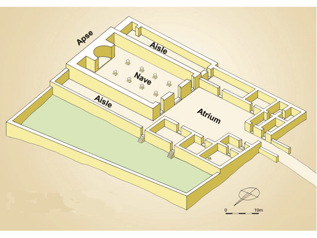 Credit: Leen Ritmeyer, © Ritmeyer Archaeological Design 2012 Fig. 8. An isometric reconstruction of the monastery, based on excavation results and visible remains.
Many times Byzantine churches were built at a particular location to memorialize a biblical event that was thought to have occurred there. That is certainly a possibility at Kh. el-Maqatir since its isolated location raises the question as to the reason for building a church at this site. There were numerous other churches in nearby villages, such as Burg Beitin only 1.0 km (0.6 mi.) northwest (Kelso 1958: 3; Kelso 1968: 53; Albright 1968: 2; Ovadiah and de Silva 1981: 208; Bagatti 2002: 33–34), Beitin 1.2 km (0.75 mi.) northwest (Conder 1881: 219, 221; Kelso 1968: 7, 53; Ovadiah and de Silva 1981: 208; Bagatti 2002: 32–33), and Kh. Haiyan 2.2 km (1.4 mi.) southeast (Callaway and Nicol 1966; Bagatti 2002: 34–35). Three suggestions have been put forward as to the event that precipitated the founding of the church at Kh. el-Maqatir. In the absence of a more detailed early Christian source or an inscription, however, these suggestions must remain speculative. They are (1) Abraham’s construction of an altar to Yahweh between Bethel and Ai (Gn 12:8, 13:3–4; Wilson 1869–70: 124; Conder 1881: 222; Sellin 1900: 1; Schneider 1934: 187–89; Albright 1968: 2), (2) Abraham’s separation from Lot (Gn 13:10–12; Dalman 1911: 14), and (3) Yahweh’s appearance to Jacob in a dream at Bethel (the church being the one that Jerome mentioned commemorated this event)6 (Gn 28:10–19; Schneider 1934: 189–90; Albright 1968: 2). We must now add a fourth option—that the church at Kh. el-Maqatir venerated the Israelite capture of Ai described in Joshua 7–8.
No portion of this article may be reproduced without written permission from the Associates for Biblical Research. This article first appeared, by invitation, on the BibleInterp.com website. It is reprinted here by permission.
Footnotes
1. On the locations of Bethel and Beth Aven, see Wood 2008: 214–28.
2. For a description and analysis of this pottery, see Wood 2008: 232–36.
3. The Amarna Letters indicate that the city-state of Shechem pursued an expansionist policy during the Late Bronze Age (Wood 1997: 245–46; Finkelstein and Na’aman 2005: 173–85).
4. For a detailed discussion of the location of the Ai of Joshua 7–8, see Wood 2008.
5. A coenobium (or cenobium) was a type of monastery in which the monks lived communally, as opposed to a laura, in which the monks lived separately as hermits around a common church.
6. Freeman-Grenville, Chapman, and Taylor 2003: 13. Curiously, the note added by Jerome concerning the church at Bethel appears in the entry for Ai (Aggai) rather than under Bethel.
References
Albright, William F. 1968. The Site of Bethel and Its Identification. Pp. 1–3 in The Excavation of Bethel (1934–1960), by James L. Kelso. Cambridge MA: American Schools of Oriental Research.
Bagatti, Belarmino. 2002. Ancient Christian Villages of Samaria. Studium Franciscanum 39. Trans. Paul Rotondi. Jerusalem: Franciscan.
Callaway, Joseph A., and Nicol, Murray B. 1966. A Sounding at Khirbet Haiyan. Bulletin of the American Schools of Oriental Research 183: 12–19.
Conder, Claude R. 1881. The Mountains of Judah and Ephraim. Pp. 193–238 in Picturesque Palestine 1, ed. Charles W. Wilson. New York: D. Appleton.
Dalman, Gustaf H. 1911. Die Ultertumswissenschaft im Institut. Palästinajahrbuch 7: 3–31.
Finkelstein, Israel; Lederman, Zvi; and Bunimovitz, Shlomo. 1997. Highlands of Many Cultures: The Southern Samaria Survey; The Sites 2. Sonia and Marco Nadler Institute of Archaeology Monograph Series 14. Tel Aviv: Tel Aviv University.
Finkelstein, Israel, and Magen, Yitzhak, eds. 1993. Archaeological Survey of the Hill Country of Benjamin. Jerusalem: Israel Antiquities Authority.
Finkelstein, Israel, and Na’aman, Nadav. 2005. Shechem of the Amarna Period and the Rise of the Northern Kingdom of Israel. Israel Exploration Journal 55: 172–93.
Freeman-Grenville, Greville S. P.; Chapman, Rupert L., III; and Taylor, Joan E. 2003. Palestine in the Fourth Century A.D.: The Onomasticon by Eusebius of Caesarea. Jerusalem: Carta.
Kelso, James L. 1958. The Third Campaign at Bethel. Bulletin of the American Schools of Oriental Research 151: 3–8.
Kelso, James L. 1968. The Excavation of Bethel (1934–1960). Cambridge MA: American Schools of Oriental Research.
Ovadiah, Asher, and de Silva, Carla G. 1981. Supplementum to the Corpus of the Byzantine Churches in the Holy Land, Part I: Newly Discovered Churches. Levant 13: 200–61.
Schneider, A. M. 1934. Bethel und seine altchristlichen Heiligtümer. Zeitschrift des Deutschen Palästina-Vereins 57: 186–90.
Sellin, Ernst. 1900. Mittheilungen von meiner Palästinareise 1899. Mitteilungen und Nachrichten des Deutschen Palästina-Vereins 6: 1–15.
Wilson, Charles W. 1869–70. On the Site of Ai and the Position of the Altar Which Abram Built between Bethel and Ai. Palestine Exploration Fund Quarterly Statement 1: 123–26.
Wood, Bryant G. 1997. The Role of Shechem in the Conquest of Canaan. Pp. 245–56 in To Understand the Scriptures: Essays in Honor of William H. Shea, ed. David Merling. Berrien Springs MI: Institute of Archaeology, Siegfried H. Horn Archeological Museum, Andrews University.
Wood, Bryant G. 2008. The Search for Joshua’s Ai. Pp. 205–40 in Critical Issues in Early Israelite History, eds. Richard S. Hess, Gerald A. Klingbeil, and Paul J. Ray Jr. Winona Lake IN: Eisenbrauns.
BibleInterp_report.pdf (1.50 mb)