After the Tabernacle was moved from the vicinity of Gilgal in the Jordan Valley to Shiloh in the Hill Country (Jos 18:1), seven tribes remained “who had not yet received their inheritance” (Jos 18:2).
One of those seven was Zebulun. For the last seven tribes to receive their inheritance, seven teams of three men each were dispatched by Joshua to survey the land and write descriptions by towns (Jos 18:4-9).
 Credit:: Barry Beitzel
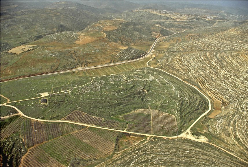
An aerial view of Shiloh, where the tabernacle was moved and the final seven tribes of Israel received their land allotments.
Upon the return of the teams, Joshua cast lots for the seven tribes’ inheritances. The third lot went to Zebulun. The following is the description of the territory Zebulun was allotted:
The third lot came up for Zebulun, clan by clan: The boundary of their inheritance went as far as Sarid. Going west it ran to Maralah, touched Dabbesheth, and extended to the ravine near Jokneam. It turned east from Sarid toward the sunrise to the territory of Kisloth Tabor and went on to Daberath and up to Japhia. Then it continued eastward to Gath Hepher and Eth Kazin; it came out at Rimmon and turned toward Neah. There the boundary went around on the north to Hannathon and ended at the Valley of Iphtah El. Included were Kattath, Nahalal, Shimron, Idalah and Bethlehem. There were twelve towns and their villages. These towns and their villages were the inheritance of Zebulun, clan by clan (Jos 19:10-16).
The identification of towns and villages (there are 18 proper names in the verses) mean we should be able to easily draw Zebulun’s borders. However, as many of the biblical locations have not been positively identified, plotting the boundaries of Zebulun’s inheritance with precision has been difficult, if not impossible. In spite of that, modern scholars, archaeologists, geographers, and investigators have attempted to pinpoint many of the sites, but there is almost no consensus on most and only a few of the places have been recognized with precision. As Saarsialo (1988:1081) noted, “although the general area of its [Zebulun’s] possession is clear enough, the boundaries cannot be exactly defined.”
With the above in mind, most authors who use maps to illustrate Bible texts (including myself in two different books1) have usually located the borders as shown on Map 1 (Rasmussen 2010:116).
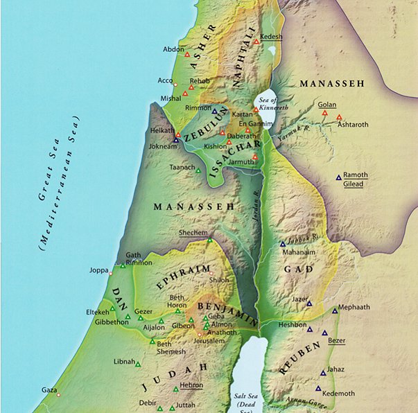 The tribal allocations as reconstructed from the book of Joshua.
Guided by the listings in Joshua 19 and using the locations of the assumed cities, towns, and the few sites known with assurance, the maps appear reasonable. Interestingly, for decades there has been consistency among geographers when drawing Zebulun’s approximate borders. As can be seen on the Map 2 (Rasmussen 2010:120), practically all the atlases conclude Zebulun was landlocked.
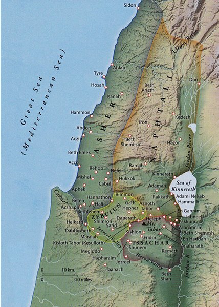 Credit: Rasmussen 2010:120
The tribal allocations of Asher, Issachar, Naphtali and Zebulon showing how Zebulun's borders resulted in it being landlocked.
Unfortunately, there are problems. The main difficulty is that a landlocked Zebulun conflicts with Jacob’s Genesis 49 prophesy regarding Zebulun’s future location as well as Moses' in Deuteronomy 33. Notice the references to “sea” in the following two texts:
Jacob said, “Zebulun will live by the seashore and become a haven for ships; his border will extend toward Sidon” (Gn 49:13).
And of Zebulun he [Moses] said, “Rejoice, Zebulun, in your going out, and Issachar, in your tents. They shall call peoples to their mountain; there they offer right sacrifices; for they draw from the abundance of the seas and the hidden treasures of the sand.” (Dt 33:18, 19)
It would be easy to dismiss the prophecies, as they were spoken hundreds of years before Zebulun’s actual distribution of territory at Shiloh. But, the truth is, the land Jacob and Moses projected for the other tribes appears to be right on the mark. Granted, the distributions are discussed in the form of poetry and somewhat difficult to understand, but a careful exegesis coupled with a map inspection and considering context will reveal the accuracy of the predictions.
To make matters more complicated, Josephus reported “The tribe of Zebulon’s lot included the land which lay as far as the Lake of Genesareth, [Sea of Galilee] and that which belonged to Carmel and the [Mediterranean] sea” (Josephus 1992: 131-2 [Ant. 5.1.22]). Josephus, as leader of the Jewish forces in the Galilee in their fight against the Romans in the first Jewish war (AD 66-73), was certainly familiar with the history of the area he was defending. If Zebulun was, indeed, landlocked, and not on either the Sea of Galilee or the Mediterranean Sea, one would wonder why Josephus would write such a description that alluded to both bodies of water?
Matthew in the New Testament adds to the confusion. He implied Zebulun bordered the Sea of Galilee when he wrote:
Leaving Nazareth, he [Jesus] went and lived in Capernaum, which was by the lake [Sea of Galilee] in the area of Zebulun and Naphtali” (Mt 4:13) and “Land of Zebulun and land of Naphtali, the way to the sea, along the Jordan, Galilee of the Gentiles” (Mt 4:15 [here Matthew is quoting Is 9:2]).
Jewish tradition also supports the implication that Zebulun was a maritime tribe. The Midrash described the banners of the tribes in the wilderness while in their encampments and on the march (Ahituv 2000:3).
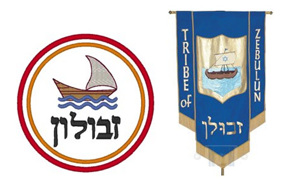 Credit: http://www.israel-a-history-of.com/zebulun.html#gallery[pageGallery]/5/
(left image) The traditional image of Zebulun is of a ship in full sail on a white background.
Credit: http://symbolsnet.com/symbols/tribe-zebulun-symbol.html
(right image) The Banner of Zebulun as imagined by an artist. A banner like this could have been carried by the tribe during its times in camp and while traveling in the wilderness.
Zebulun’s banner was described as a ship on a white background (Jewish tradition: Zebulun’s stone on the High Priest’s vest was a diamond, ergo white (Ex 28:18 NASB). An organization of modern day Sea-Scouts in present-day Israel is named Zebulun [Ahituv 2000:3]). There is an apocryphal book titled The Testament of Zebulun (Platt 2006) which is what Zebulun supposedly said to his children and grandchildren before he died. The book tells how he became a sailor and was a fisherman by summer and a shepherd by winter. Other Rabbinic legends tell about members of Zebulun who were successful seamen and brought income to Issachar in order for Issachar to stay home, study the Torah and be great teachers, lawyers and diplomats (Ptai 1992:56).
How does one explain these Bible passages and extra-biblical evidence as they pertain to Zebulun? Smith (2013) simply concluded “the statement of Josephus is probably in the main correct, that is [the border] reached on the one side to the Lake of Gennesareth and on the other to Carmel and the Mediterranean. On the south it was bounded by Issachar, who lay in the great plain or valley of the Kishon; on the north it had Naphtali and Asher.”
In his classic exposition of Genesis, John Skinner (1912:526) tried to sort out the arguments: “the tribal boundaries fluctuated greatly in early times, and at the date of the poem [in Gen 49] Zebulun had access at some point to the sea.” More recently, B. Mazar (1992:129-130) had a similar view. But those caveats do not explain Matthew’s identification of Zebulun, as well as Naphtali, as being on the Sea of Galilee. Aharoni and Avi-Yohnah solve the problem this way: “The list of border points is drastically abridged and, in its present form, the original detailed description remains only in places of special interest, such as near Jerusalem” (1977: see Map 72’s narrative). Those opinions, of course, argue for a late date of writing for both Genesis and Joshua, a position I do not hold.
That Naphtali was to have touched the Sea of Galilee is not in question since it is clear in Joshua 19 that its cities did include those on the west and south of the Sea of Galilee. It could be that at the time of Jesus, Zebulun also bordered the Sea, not as shown in modern maps or as described in Jos 19. Since Matthew was a tax collector at a key junction of the highway south of Capernaum on the Sea of Galilee, his collection station might well have been on or near the border between the two tribal allotments of Naphtali and Zebulun. Curiously, the time of Matthew’s writing of his book coincides with the writing by Josephus and his identification of Zebulun being at the Sea of Galilee.
After reviewing numerous authors’ thoughts on the matter of Jacob’s prophesy, Wayne Jackson (2017:4, 5) described several options scholars have used to explain Jacob’s prophecy. (1) The tribal allotment for Zebulun in Genesis does not demand the allotment actually bordered the Mediterranean Sea. Some scholars opine that the Hebrew grammar can suggest the tribe was to live near or towards the Sea. (2) The border Zebulun’s territory was close enough to the seas that they gained wealth from the sea and treasures of the sand. (3) The prophecies refer to an early period in Israel’s settlement of the land when Zebulun and Issachar were attempting to establish themselves on the Sea of Galilee. (4) The borders refer to Zebulun’s Solomonic borders. (5) The language in Genesis is symbolic, hinting that Zebulun would be associated with sea commerce. (6) The description of the borders does not refer to the actual tribal boundaries but to where the tribe might have roamed and lived from time to time. Jackson summarizes the many theories in this manner:
It is an odd circumstance that some scholars claim Zebulun never did attain the land prophesied by Jacob, while other equally competent authorities argue that the tribal settlement did satisfy the language of the Genesis text. In the meantime, all [emphasis in original] admit that the boundary specifications of Joshua 19:10-16 are quite vague — some cities not being mentioned by name, while others still lie buried in the dust of antiquity — not yet identified! (Jackson 2010:5)
So, there are two issues that need to be resolved: one is where was Zebulun’s border on the east at the Sea of Galilee in the Old and New Testaments; and second where was the border on the west?
I’ll deal first with the west. Today, Bible geographers usually draw Asher’s territory extending south to Mt. Carmel and incorporating part of the western foothills that border the Acco Plain (Jos 19:26). Refer to Map 2. At Carmel the description continues: the border proceeded east toward Beth Dagon (which is actually northeast but ancient Hebrew only used the four cardinal points of the compass) and in the process “touched” Zebulun near or at the Valley of Iphtah El. The Asher listing of towns that were inland and on the western edge of hills and are known indicates most modern Bible geographers have marked the border well. However, that does not answer the question: how could Zebulun be at/near/on the Mediterranean as mentioned in Josephus? Some scholars believe there is evidence that the tribe of Zebulun penetrated the Plain of Acco, likely under the patronage of several Canaanite cities (Aharoni 1979:18). My conclusion is that Zebulun’s western border, high on the hills that overlooked the Plain of Acco and the Mediterranean, was only a half-day’s walk (8 mi or 12.8 km) to the shore. Further, once on the Acco Plain, it was an easy day’s walk north to Acco (7 mi or 11.2 km). Locating the Asher/Zebulun border in this way seems to validate the conclusion (1) and (2) in Jackson’s analysis, above.
The second problem is the eastern border. It is a bit more complicated. The tribe on Zebulun’s north and west was Naphtali (see Map 2). The list of towns in Jos 19:33 reveals Naphtali’s border incorporated the whole of the Sea of Galilee. There are two ancient ports on the southwest corner of the Sea of Galilee: Beth-yerah and Sennabris. Limited excavations at both locations have shown them to have been anchorages from Hellenistic times, still in use today for small fishing and pleasure craft. There is a possibility the same locations were fishing or commerce ports in ancient, pre-Roman/Greek, times, too. Carefully drawing Zebulun’s borders in the western-most part of her territory, according to the cities mentioned in Jos 19, places the Zebulunites only 12 mi (7.5 km) from the Sea of Galilee; again, a one-day walk. However, Naphtali controlled other more northerly anchorages on the Sea that in Joshua 19:35 are described as “fortified,” Hammath and Chinnereh. Therefore, Naphtali may not have used the small, unfortified southerly ports of Beth-yerah and Sennabris leaving them open for the Zebulunites to occupy. Here again, this analysis lends credence to Jackson’s suggestion of options (1) and (2), above.
Using the above information may help clarify the Old Testament prophecies of Moses, Jacob, and Isaiah as well as Josephus’ description of Zebulun having access to the Mediterranean Sea and the Sea of Galilee. Using that logic supports Matthew’s hint that the Sea of Galilee was an integral part of Zebulun’s territory. Of course, there are still many unanswered questions. In the future, as archaeologists unearth more and more of the less well-known locations in this area, it may be possible to more precisely mark Zebulun’s borders and, in fact, learn that it did have direct access to both the Mediterranean Sea and the Sea of Galilee. In the meantime, perhaps this essay will help explain why Jacob, Moses, Isaiah, Josephus and Matthew referred to the mysterious borders of Zebulun as extending from the Sea of Galilee to the Mediterranean Sea.
Note
1) Maps used throughout the books (Martin, Beck and Hansen: 2009 and 2011) were designed by the author.
Bibliography
Aharoni, Yohanan, 1979 The Land of the Bible: A Historical Geography. 2d rev. ed. Trans. A.F. Rainey from Hebrew. London: Burns & Oates.
Aharoni, Yohanan and Avi-Yonah, Michael, 1977 The Macmillan Bible Atlas (Rev ed). New York: Macmillan.
Ahituz, Shmuel, 2000 Zebulun by the Sea. Pp. 3-7 in Studies in Historical Geography & Biblical Historiography, eds. G. Gad and M. Weinfield. Boston: Brill.
Drum, Walter, 2017 Zabulon [sic] in The Catholic Encyclopedia. Vol 15. New Advent, http://www.newadvent.org/cathen/15739b.htm (accessed May 10).
Jackson, Wayne, 2017 What About Jacob's Prophecy Regarding Zebulun? ChristianCourier.com, https://www.christiancourier.com/articles/1141-what-about-
jacobs-prophecy-regarding-zebulun (accessed May 10).
Josephus, Flavius, 1992 The Works of Josephus. Trans. W. Whiston. Peabody, MA: Henrickson.
Martin, James C.; Beck, Jack A.; and Hansen, David G., 2009 A Visual Guide to Bible Events. Grand Rapids, MI: Baker.
Martin, James C.; Beck, Jack A.; and Hansen, David G., 2011 A Visual Guide to Gospel Events. Grand Rapids, MI: Baker.
Mazar, Benjamin, 1992 Biblical Israel: State and People. Jerusalem: Magness.
Midrash, 1907 Tales and Maxims from the Midrash. Samuel Rapaport, ed. New York: H. P. Dutton.
Ptai, Raphael, 1998 The Children of Noah: Jewish Seafaring in Ancient Times. Princeton: Princeton.
Platt, Rutherford H., 2006 The Testament of Zebulun. Whitefish, MT: Kessinger Legacy Reprints.
Rasmussen, Carl G., 2010 Zondervan Atlas of the Bible. Grand Rapids, MI: Zondervan.
Saarisalo, Aapeli, 1988 Zebulun. Pp. 1181-2 in International Standard Bible Encyclopedia. Fully revised, 4, Gen ed. Geoffrey Bromiley. Grand Rapids: Eerdmans.
Shea, Mark, 2014 Land of Zebulun, Land of Naphtali, Galilee of the Gentiles. Patheos Catholic, http://www.patheos.com/blogs/markshea/2014/01/land-of-zebulun-
land-of-naphtali-galilee-of-the-gentiles.html (accessed May 2, 2017).
Shomeyer, Yehudah, 2013 The Tribe of Zebulon. RayBaSH’s Ramblings, https://raybash.blogspot.com/2013/03/the-tribe-of-zebulon.html (accessed May 8, 2017).
Skinner, John, 1912 ICC: Genesis. New York: T&T Clark, an imprint of Bloomsbury.
Smith, William, 2013 Zebulun. Smith’s Bible Dictionary: Revised and Updated. Bible Study Tools, http://www.biblestudytools.com (accessed May 1, 2017).