In Part One of this study we looked at issues relating to the general validity of testimony as a tool for evaluating truth-claims, and in Part Two discussed ways to accommodate these testimonies in the search for Noah's Ark without throwing science out on its ear, just exercising care to use it with minimal assumptions about unknown initial conditions. Since geology is supposedly an objective science rather than one that assumes unknowable initial conditions, in Part Three we now look at the claim that geological studies have proven that Mt. Ararat is a young volcanic peak that could not have existed at the time of the Flood..
Geological Studies: A Definitive Criterion of Truth?
Does any geological information exist that can legitimately be interpreted in favor of Mt. Ararat being the landing-place of the Ark, as the “two or three” principle for testimonies apparently requires? Or is there a way to view geological data in a way that does not proscribe Ararat as being the mountain of the Ark? Some say no:
In support of casting the net more widely for the Ark, some geologists argue that the volcanic Mount Ararat did not erupt until after the Flood and therefore the Ark could not have landed there (Anne Habermehl, A Review of the Search for Noah’s Ark, Proceedings of the Sixth International Conference on Creationism (2008), pp. 485–502).
Obviously, if Mt. Ararat did not yet exist at the time Noah was floating on the Flood waters, it could not have been the Ark’s landing place, and we must look elsewhere. But we must ask, does geology conclusively prove Mt. Ararat is too young?
The first formal studies of Ararat geology were performed by Hermann Abich (1845) and M.M. Blumenthal.1 A recent summary of the secular scientific consensus about Ararat geology is the following:
The volcanic massif from which the cones of Great and Little Ararat rise covers approximately 1,200 km2 and towers on the southeastern side above a Paleozoic basement slit by the trenches filled with recent deposits which form the Araxes and Doğu Bayazıt plains. The two principal cones are for the most part composed of recent (Upper Pliocene and Quaternary) andesitic lavas, but have a complex morphological history as there are several satellite cones and some lateral flows of more recently erupted basalt.2
The claimed Upper Pliocene and Quaternary dating of the majority of the extruded lavas makes them much too recent for their layers to have supported the Ark after the Flood (although one must note the hedging words above, “for the most part,” which acknowledge the real possibility that lower, earlier layers may have been much older). This dating has raised doubts in the minds of scientifically-sensitive Christians over the validity of all the testimonial data. Dr. John Baumgardner of Los Alamos National Laboratory, relying on a paper by Mehmet Keskin (2005), in a personal communication to Anne Habermehl (quoted on page 491 of her 2008 International Creation Conference paper), pointed out that
the oldest radioisotope age for the volcanic rocks from which Mt. Ararat constructed is 1.7 million years. If we apply the results of the RATE research that strongly indicates accelerated nuclear decay during (and also immediately after) the Flood, a radioisotope age of 1.7 million years falls during the Ice Age and therefore during the interval of a few centuries after the Flood. I consider this to be a solidly defensible piece of evidence that the onset of the massive volcanic eruption which produced Mt. Ararat occurred after the Flood by at least a hundred years. The maps in this paper [Keskin, Domal uplift and volcanism in a collision zone without a mantle plume: Evidence from Eastern Anatolia, http://www.mantleplumes.org/Anatolia.html] also indicate that the volcanic eruptions associated with those that formed Mt. Ararat cover the Eastern Anatolia Accretionary Complex (EAAC) rocks and, apart from local alluvium, are the most recent geological features in the area. Moreover, they are subareal [sic, subaerial], which means these eruptions occurred after the area had been uplifted above sea level. All these lines of evidence support the conclusion that Mt. Ararat is a volcanic mountain that formed in its entirety after the Flood had ended.3
For our purposes we do not need to know how the RATE (Radioisotopes and the Age of The Earth) studies correlate to Keskin’s date to lead to the conclusion Mt. Ararat arose during the Ice Age. Nor need we question the general methodology used in radioisotope dating volcanic rocks. But it is important to observe that in coming to these conclusions, Dr. Baumgardner is implicitly trusting the validity of the Keskin data—a confidence which may or may not be justified. He goes further to say that Keskin’s date marks “the onset of the massive volcanic eruption which produced Mt. Ararat,” rather than more accurately claiming it was the date yielded by the specific rocks which were sampled. The question must be asked, what volcanic rocks were tested, and are the results reliable?
Which Rocks Were Dated?
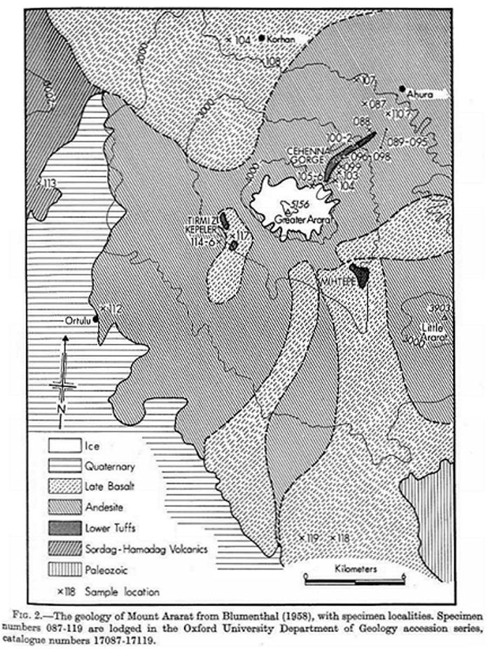
The reason this must be looked at is because it is known there are different types of rocks on Mt. Ararat, with different compositions and yielding different dating results. Most of the volcanics on Mt. Ararat are extruded andesites and basalts, very common all over the mountain. These are presumably the ones sampled by those who did the dating for Keskin. However, there are some much rarer rock outcrops known as the Lower Red Tuffs. Their locations are noted on the Blumenthal map (“Fig 2”) below:
A paper by Richard St. John Lambert et al (Journal of Geology, 1974, vol. 82, pp. 419–438) entitled, “Chemical Petrology of a Suite of Calc-Alkaline Lavas from Mount Ararat, Turkey,” presented a study of these rocks. The Introduction of that paper summarized its findings thus:
Blumenthal gave a general map, delimiting areas of Lower Red Tuffs, Andesites, Later Basalts, Volcanics not of Ararat, and the surrounding Carboniferous to Recent sediments (fig. 2). Collection of in situ specimens and the stratigraphy of the volcano is hindered by absence of bedrock exposure on Ararat, except in localised areas, such as the gorge of Gehenna (or Ahora) between the summit of Great Ararat and the village of Ahora (or Aguri), the Kirmiz Tepeler (Red Hills) which lie SW of the summit and Mihtepe, SE of the summit. Of these areas, the two former expose red haematitised lavas, of greater age than the “andesites” of the main structure (Blumenthal, 1958) and which form a petrographically and chemically distinct suite, the Lower Red Tuffs, believed to be co-extensive with the low-Y series of this paper. The fresh Later Basalts can be clearly distinguished as black, soil-free flows on the flanks of the mountain, erupted from fissures in postglacial time (emphasis added).
Besides taking special note that the Lower Red Tuffs are older than the dominant structural rocks, observe also these words: “Collection of in situ specimens and the stratigraphy of the volcano is hindered by absence of bedrock exposure on Ararat.” This is the root of my concern about the validity of the Keskin dating. The Blumenthal map shows that nearly all of the Lower Red Tuffs are exposed only in the Ahora (Cehenna) Gorge, with rare isolated other exposures in the region. Lambert’s Lower Red Tuffs samples numbered 096–098 were taken from the Gorge. Of these Lower Red Tuffs the report concludes that the low-Y [yttrium, a rare-earth mineral] rocks of this type were “generated under more hydrous conditions than prevailed during the evolution of the later high-Y series” (emphasis added). Although secular scientists will not consider it an option, these words should immediately alert us to look at this as a possible indication of extrusion of the oldest lavas through Flood waters. But these, presumably the oldest volcanic rocks on Ararat, are rarely exposed and hard to get at, and I have not found reason to trust that it was these old rocks—perhaps not even the oldest, since I am not aware that any actual cores have ever been performed into the heart of the mountain—were the ones dated by Keskin.
Here is a sampling of a few comments from the Lambert paper:
- On the basis of Blumenthal's map (fig. 2) the low-Y series are not extensively exposed on the volcanic pile. (In other words, they are scarce.)
- Their [the low-Y series rocks] mineralogy and chemistry suggest a different process of differentiation to that affecting the high-Y series. (Therefore, a possible mid- or even pre-Flood origin should be on the table.)
- The Ararat rocks resemble calc-alkaline rather than oceanic volcanics in their strontium isotope results. (A geochemical quality to note when we examine the Keskin data in detail.)
- The model that emerges from this is of an intermediate parental magma (Si02 near 60%) crystallizing at different times under different physical controls, which we believe were most probably dominated by variations in PH20. (In other words, water content was a key difference in the rocks, and the external conditions under which they were extruded could have been quite different.)
From this it should be clear that if only the andesites that extensively litter most of Mt. Ararat or the Late Basalts were tested—or even if the Lower Red Tuffs were tested, and they are not, in fact, the oldest rocks at the heart of Mt. Ararat—we cannot depend on the Keskin data to tell us when the mountain first began rising. Without knowing more about the specific rocks that were dated, no evidentiary basis exists for claiming the entire Ararat volcano arose during the Ice Age. All we can confidently say is that the rocks which were dated were from an Ice Age eruption—assuming, again, that Keskin’s dating and the RATE date interpolation made from it are both correct. Caution in drawing firm dating conclusions from the data in the literature is justified because it conflicts with following the “two or three” principle concerning the testimonies that place the Ark on Mt. Ararat.
Overview of the Keskin Data
With the Lambert data fresh in our minds, let us examine some things that Keskin reported; the sheer volume of that research and its derived interpretations permit us to barely skim the surface. Following is Keskin’s Figure 7, giving the radiometric dates of his samples. The “1.7” near the right border designates the initiation age of volcanism at or near Mt. Ararat in terms of millions of years ago (Ma):
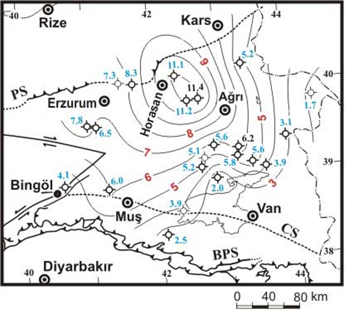
The caption with the above figure reads, “Figure 7. Distribution of the oldest radiometric ages of the volcanic units. Ages are from Pearce et al. [1990], Ercan et al. [1990] and Keskin et al. [1998]. Initiation ages of the volcanism are contoured in 1-Myr intervals. PS: Pontide suture, BPS: Bitlis-Poturge suture, CS: inferred cryptic suture between the EAAC and BPS. Figure from Keskin [2003].”
To date I have been unable to confirm from Keskin’s voluminous work whether the specimens he used for Mt. Ararat dating were obtained from the Lower Red Tuffs or from other rocks. Until this is confirmed, Keskin’s 1.7 Ma date for the onset of Ararat volcanism must be accepted provisionally, not definitively. Reason to suspect the dated samples may not have been taken from the Lower Red Tuffs arises from that fact that Lambert said his specimens from Ararat were clearly “calc-alkaline lavas,” which a chart from Keskin4 indicates is the typical geochemical profile of the very oldest volcanics found especially in the Erzurum-Kars plateau, where they were dated as high as 11 million years ago. Keskin’s Fig. 8 is reproduced below for ready reference in this discussion:
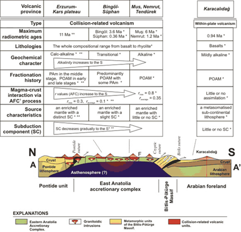
This chart shows that the calc-alkaline lavas, characteristic of the Erzurum-Kars Plateau that Mt. Ararat is a part of (see below), are consistently the oldest ones. This is inconsistent with the conclusion that Mt. Ararat is only an Ice Age volcano. In view of the importance of giving proper place to the testimonial data as part of the “big picture,” it is fair to say that researchers are not presently in a position to definitively date the entire Ararat massif to the Ice Age. All we may assert is that the Ice Age saw a massive eruption episode on Mt. Ararat.
Miscellaneous Observations on Keskin
There are other problems with relying on Keskin’s data, even inconsistencies within it. A friend who wishes to remain anonymous read the Keskin paper in detail and shared several pertinent observations, including the following:
- Keskin made the point that the Eastern Anatolia region shows “volcano-sedimentary successions.” Sediment, in the professional geological literature, is safely understood as water-deposited materials, such as sandstones, shales and limestone. If sediment superposes over a volcanic layer, it indicates at least some of the Ararat volcanism is mid-Flood, not post-Flood. (Crouse—see below—objected to Burdick’s characterizing the interbedded sediments he observed as water-borne, but Keskin’s comments appear to vindicate Burdick.)
- If one wants to follow Keskin's discussion of tectonic history modeling, one has to identify which plate fragment region Ararat belongs to. But Keskin seems to say two things on that. In his listing of the five plate fragments in Eastern Anatolia, he clearly states Ararat belongs to the Northwest Iranian Fragment (NIF): “Five different tectonic blocks are recognised in North-Eastern Anatolia (Fig. 5): ...II. The Northwest Iranian Fragment. The eastern part of the Erzurum-Kars Plateau (i.e. Horasan, Aladag, Kagizman, Kars areas and Mt. Ararat) overlies this tectonic block (Keskin et al., 1998).” To follow this description, here is Keskin’s Fig. 5, where the gray area is the NIF, and the pink areas within it are exposures of the Erzurum-Kars Plateau (EKP):
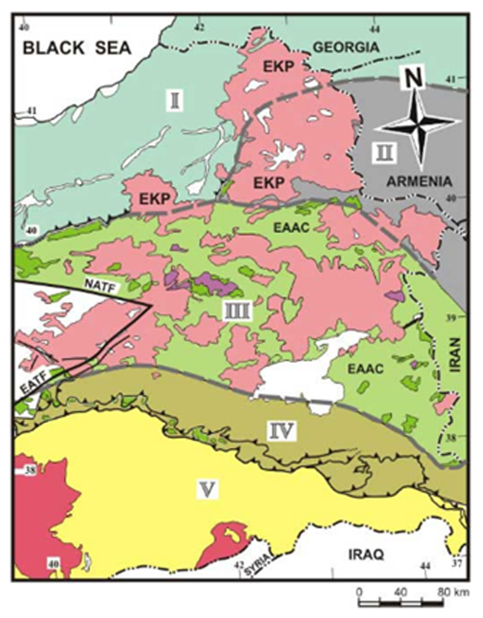
However, looking at Keskin’s Fig. 4, Mt. Ararat (“Ag”) is labeled as “Collision-related volcanic units underlain by the Pontides and EAAC” (East Anatolian Accretionary Complex, plate fragment III in Fig. 5):
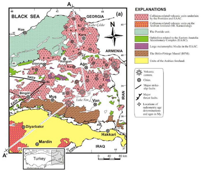
The Pontide fragment is Fragment I some 100 miles to the west or northwest of Ararat. His Fig. 5 with the plate boundaries shows Ararat about 20 miles away from the EAAC and within the NIF. So, is Mt. Ararat within the NIF, the EAAC, or the Pontide Fragment region?
- The general region has a dome uplift (anticline), in which the center has the oldest rocks and the exposed rocks due to erosion shearing off of the anticline dome are progressively younger as one travels away from the center (the “anticline” has to have this progressive young age with distance factor otherwise it is called an “antiform”). Keskin shows that pattern in his Fig. 7. But this applies to the general plateau around Ararat. The question is how much of Ararat itself is stratovolcano (or other volcano) accumulation, and how much is due to a violent upthrust of sedimentary and maybe granitic rock layers (which could only have occurred during, not after, the Flood).
- Finally, it appears Dr. Baumgardner has mistakenly read Keskin's maps and put Ararat within the EAAC tectonic plate fragment, when Keskin's Fig. 5 and text put Ararat within the NIF. Maybe he mistakenly thought the city of “Agri” was Ararat (which is actually about 70 miles to the east of Agri). The city of Agri is indeed within the EAAC. I noticed some confusion on Keskin's part, too. If Baumgardner mistakenly thought Ararat was in the EAAC instead of NIF (and if Ararat in fact belongs in NIF), it may invalidate his whole analysis.
In short, Keskin’s paper appears problematic on multiple fronts, making it inadvisable to rely on him for dating Mt. Ararat to the Ice Age until these confusing, apparently conflicting details are resolved.
Although it is unsubstantiated at this point, in passing I mention that Turkish geologist Dr. Salih Bayraktutan, a native of the Ararat region, has insisted for years (personal communications) that he has samples from within the Ahora Gorge that prove Mt. Ararat was in existence at the time of the Flood. We await his finishing and publishing that research before we can rely on it, but it sounds intriguing.
The Stratovolcano Form of Mt. Ararat Cannot be Reconciled with Noah’s Ark
The overwhelming majority of geologists and volcanologists agree that Mt. Ararat bears the form of a typical stratovolcano—one built up of alternating layers of relatively thick magma, resulting in the typical steep cone shape typified by Japan’s Mt. Fuji. Another type, known as a shield volcano and characteristic of the Hawaiian Islands, is comprised of a much more fluid magma that resists being “stacked up,” yielding a relatively low dome shape. For these reasons, those who have claimed Mt. Ararat is a shield volcano—notably Creation Research Society geologist Clifford Burdick—are viewed with derision by researchers, who assume that anyone making such an egregious error could not get anything else right!
I accept that the evidence points to Mt. Ararat being a stratovolcano. However, some would add a corollary to this I do not agree with—that the stratovolcano form requires it to have been built up subaerially (under air, rather than under water). It is often assumed that the steep-sided form of a stratovolcano is a function of being built up under air. However, this is NOT a requirement. The Dictionary of Geological Terms, published by the American Geological Institute, gives the authoritative definition of a stratovolcano thus: “A volcano that is constructed of alternating layers of lava and pyroclastic deposits, along with abundant dikes and sills. Viscous, acidic lava may flow from fissures radiating from a central vent, from which pyroclastics are ejected.” That is the entire definition given in the book, and it says nothing about subaerial formation being a requirement.
Australian geologist Max Hunter has argued that Mt. Ararat may have arisen during the Flood event (see: Was Mount Ararat a Submarine Stratovolcano?). The Smithsonian Global Volcanism Program online entry for the Zealandia Bank depicts a submarine stratovolcano with no obvious differences in external form from one formed subaerially, which would support Hunter’s claim:
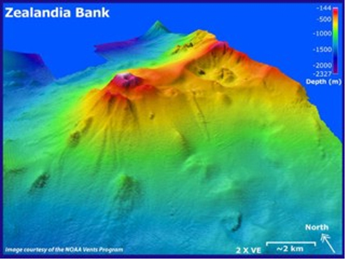
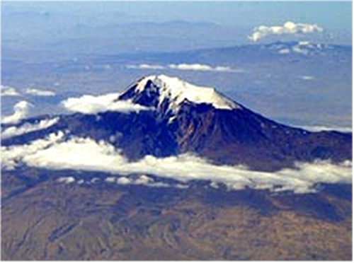
Compare the Zealandia Bank picture with the next one of Mt. Ararat, from http://www.pbase.com/bmcmorrow/image/34205613 The overall morphological similarities are apparent:
Some have explained Zealandia Bank as a subaerial stratovolcano that was submerged when the Ice Age glaciers melted, resulting in a worldwide rise in sea level. But that claim conflicts with generally accepted information. According to the depth color coding, the base of Zealandia Bank begins about 1200 meters (roughly 3950 feet) below sea level. However, the greatest sea level drop during the last glacial maximum was only about 120–135 meters (roughly 400 feet). “During the last glacial maximum, when the last ice age was in full swing and continental ice masses variously reached their greatest extents, considered to be the millennia centered about 21,000 calendar years ago, sea level reached 120 meters (~400 feet) lower than recent eustatic mean sea level”.5 This means Zealandia Bank had its genesis some 3550 feet below the ocean surface at its most shallow point, making it doubtful it could have begun formation subaerially.
I sent an e-mail to Dr. David Pyle, an Oxford University (UK) volcanologist, in March 2011 and asked him, “Is it possible for a stratovolcano to form completely subaqueously, yet display a morphology essentially the same as one formed subaerially?” He kindly replied back, “Yes—there are many submarine volcanoes, which to a first-order may have the same sorts of gross morphological features as subaerial volcanoes. Of course, the products of submarine volcanism are quite different from the products of sub-aerial volcanism, and they can be quite readily distinguished on the basis of the nature of their deposits.” This professional opinion was echoed in comments by another Ph.D. geologist (personal communication, name withheld at his request):
The style of eruption is related to the nature of the magma basalt/andesite/rhyolite, its gas content and degree of interaction with water (esp. ground water). Many volcanic edifices/region show a mix of flow compositions related to different magma batches that have erupted from the edifice/region during the eruptive history of the area.
There are multiple examples of underwater stratovolcanoes—yes they have some differences but many similarities i.e. made up of pyroclastics (yes you can have submarine pyroclastic flows and rainout), lavas, debris flows and that classical shape.
Interestingly there are stratovolcanoes buried by 100's to 1000's of meters of sediment (also overlaying sediment)—these can be clearly seen on seismic (with their classical shape) and in some cases have been drilled (and cored) as part of oil exploration activity. The Kora complex is an example. These volcanoes have to be formed during the flood to have so much sediment deposited over and under them, so must have formed in a submarine environment.
From these observations, we can confidently assert that an undersea stratovolcano with a form like that of Mt. Ararat can certainly exist. But why does pointing this out matter? It helps explain the chemistry of the low-Y Lower Red Tuffs on Mt. Ararat and their “more hydrous” origin, different from that of the high-Y Later Basalts. Understanding Mt. Ararat began its life as an underwater magma-extruding fissure resulting from the breakup of the “fountains of the great deep” (Gn 7:11) fits with the geochemical analysis of the Lower Red Tuffs, giving reason to doubt Ararat was erected due to the action of colliding crustal plates years after the Flood. The initial eruption was probably underwater, and over the course of the year that the Flood lasted, the Ararat volcano continued to rise, from a combination of both crustal uplift and magma extrusion, until it was high enough for a cooler part of the mountain to snag the Ark.
One more factoid encouraging us to entertain the idea that Keskin’s hypothesis may not apply to Mt. Ararat is that, at least in the case of the Hawaiian volcanoes, the source of magma is thought to be the upper asthenosphere, not friction from plate collisions. This may offer another explanation for the difference in geochemistry between the “more hydrous” Lower Red Tuffs and the more recent andesites and Later Basalts: the Lower Red Tuffs had a hot-spot origin and tapped into magma directly from the asthenosphere before and/or during the Flood, while the more recent volcanics were extruded by a process more in accord with Keskin’s plate collision model. This idea requires further research, but is an attractive explanation for the known differences in geochemistry of the volcanic rocks of Mt. Ararat.
Attacking Reputations Rather than Data: Burdick
Now, let us turn to consider the Ararat research of Clifford Burdick, first published in the Creation Research Society Quarterly, 1967, pp. 9–10. “Throwing the baby out with the bathwater” is an aphorism applicable to this research, because once people learn he goofed by calling Ararat a shield volcano and, moreover, did not receive his doctoral degree from a properly accredited university, they tend to disregard all of Burdick’s field observations on Mt. Ararat as tainted. The comments of Habermehl (490) are typical: “all of Burdick’s claimed academic degrees were bogus.” For this reason they see no need to examine his actual field research on its own merits. This is a mistake, because those field observations were undergirded by a considerable background in geology, and were corroborated by other later researchers with PhD’s. The validity of those observations is a matter independent from how he obtained his degrees and his probable mislabeling of Ararat as a shield volcano. Who among us has never made an error in print, and is entitled to cast the first stone?
Burdick’s field data is not inconsistent with what later researchers such as Lambert et al have reported, and offers evidence that fits with the testimonies that the Ark was seen on Mt. Ararat. One suspects this support for Mt. Ararat is an underlying reason he is attacked so vigorously. Despite this, Dr. Jerry Bergman’s investigations of Burdick in the Creation Research Society newsletter (Creation Moments 15-4 and 15-5, 2010) upheld his educational preparedness to perform reliable field geology:
In 1917 he earned a BA in chemistry from Milton College, Milton, Wisconsin, with excellent grades: all A's and B's except three classes including freshman English. He had difficulty with writing his entire life and may have been dyslexic...Burdick then completed all graduate work required for an MS in geology at the University of Wisconsin. Although he earned a total of 34 semester hours in geology, botany, and genetics, all with good grades, he was denied his degree. Burdick claimed that his rejection of Darwinism was openly the reason...Burdick was later accepted into the geology Ph.D. program at the University of Arizona. He then completed all of the requirements (a total of 88 semester graduate hours in geology, paleontology, paleobotany, petrology, and stratigraphic geology), again all with above-average grades. He thus earned a total of 330 semester hours, most in science. Although Arizona never did grant him a degree, Milton College, in recognition of the work he had accomplished toward a Ph.D., granted him an honorary doctorate of science in 1973.
From these two carefully researched articles by Bergman, it is clear that Burdick had considerable training in geology. Let us now take a look at some of the things he reported.
The Significance of Interbedded Sediments
Dr. Andrew Snelling, widely regarded as an authority in Flood geology, in a personal communication quoted by Habermehl (491), stated that “there is agreement among the leading creation geologists that it (Ararat) is a post-Flood mountain that sits on late Flood/post-Flood limestone.” (Who those “leading creation geologists” are is not stated.) In a personal communication to me (8/11/2008), David Vonderheide of the United States Geological Survey echoed Snelling’s understanding, but went further:
One thing is certain...Ararat itself sits atop sediments that are clearly Flood-deposited, and that in itself dates the volcano at the very earliest to the late Flood. The sediments are sandstones, shales and limestones, both folded and flat-lying. The volcano sits within a highly faulted area that appears to have been pulled apart, forming a graben or graben-like structure. There is indeed an older series of flows and ash layers, a large mound that the cone of Ararat is built up on. Those bottom flows may have formed in the closing days of the Flood, followed by eruptions of ash as well as lava in the post-Flood period.
To date, Dr. Snelling has not explained how he knows, without the shadow of a doubt, from actual field research, that the entire Ararat massif sits atop Flood-deposited limestone. Lacking cores into the heart of Mt. Ararat to see exactly what is in there, his statement, “Ararat sits on late Flood/post-Flood limestone,” should best be understood to mean that the most apparent, externally observable volcanic layers overlie regionally observable sedimentary layers. Those sedimentary layers are then extrapolated, presumably on the basis of Keskin’s plate collision model rather than actual cores into the root of the mountain, to have existed long before the volcanic fissure that gave birth to Mt. Ararat broke through the earth’s crust. Such an extrapolation, however, is no basis for making absolute claims with explicit scientific warrant; only field research and cores can provide that degree of certainty. This is especially important when making a claim that goes against the biblical “two or three” principle for dealing with testimony.
Consider this alternative scenario, which takes the testimonies into account. We have a pre-Flood or mid-Flood volcano that had its beginning over a hot spot, a thin area of the crust where the hot asthenosphere is near the surface, as is supposedly the case under Yellowstone Park and the Hawaiian Islands (and as Keskin’s Fig. 8 cross-section diagram indicates is the case under Mt. Ararat, too). The Flood would have dumped sediment on top of Mt. Ararat, such as in the case of the Kora complex (mentioned above). But this sediment dump would not have put out the internal fires. As the Flood progressed, low-Y lava would have continued trying to force its way to the surface. Furthermore, Keskin and Burdick have both stated there was “doming uplift” of the region, which would have uplifted the primordial Ararat and contribute to causing the loose, unconsolidated sediments from the early stages of the Flood on its slopes to slough off. This would increase the likelihood that the original Mt. Ararat would have poked through its sediment blanket and continued to episodically build itself higher, resulting in some alternating sediment and lava layers. Retreating water during the latter stages of the Flood would have tended to erode loose sediments from its slopes, keeping Ararat from being completely buried. The continued doming uplift of the region—which I suspect was related to isostatic rebound as the Flood waters went into “valleys” in the sea floor, deepening them in the process—would have allowed Mt. Ararat, built up from the Lower Red Tuffs that first broke through the basement granites, to provide a landing-place for Noah’s Ark on its slopes.
I submit that the above scenario makes perfect logical sense, finds a place for the Lambert and Keskin data (but not all of their secular interpretations of it), and cannot be disproved except by field research, including cores into the heart of Mt. Ararat. We do not have such cores, but we DO have some field research. Does that done by Burdick support or undermine this model?
First, recall a point mentioned earlier about Keskin’s data, that he reported that the Eastern Anatolia region shows “volcano-sedimentary successions.” Burdick likewise reported sedimentation in his 1966 report, originally in CRSQ and quoted on page 203 of the PDF at http://noahsarksearch.com/The_Explorers_Of_Ararat_1945-1974_Clifford_Burdick.pdf.
There were several eras of volcanic events. Professor Nazmi Oruc of Atatürk University at Erzurum told me that his soil sample study from well drillings in the Aras valley showed at least three periods of volcanism, the layers of lava being interbedded with sediments...West-southwest of Ararat and west of Diyadin occurs a thick bed of basalt overlaid with limestone, apparently conformable. A river flows through the limestone, and the latter has been folded into an anticline, which has fractured along the axis. This fracture has permitted ground water to penetrate down to the limestone-lava contact. The lava was apparently not very cool when the limestone was laid down, for it heated the water to the boiling paint, and the steam pressure has forced steady geysers to shoot from the surface. This water flows down the sides of the geyserite or tufa and is caught in pools similar to the hot water pools in Yellowstone Park...The orogeny of the hot springs bespeaks fast tectonic activity, cataclysmic action, and does not fit long-ages geology. Seemingly, basaltic extrusion was quickly followed by deposition of limestone before the hot lava cooled.
Note well those words, “interbedded with sediments.” It was a Turkish professor making this claim, not Burdick, so those who feel Burdick’s geology is suspect cannot use that distrust as a reason to disregard this information. Furthermore, the drillings revealing the interbedding were in the Aras valley, the river valley immediately below Mt. Ararat on its east side, so the observations made there would be expected to reflect Ararat activity. As creationists who attribute virtually all sedimentary rocks to the Flood, we expect sediment deposition to have taken place continuously from the time the Flood began until its waters began to subside, and even for some time thereafter as the decreased turbulence of the water allowed minerals to precipitate out of solution. If lavas were erupted episodically from Mt. Ararat while sedimentation was ongoing, we would get interbedding results like those reported by the Turkish geologist Oruc. By the principle of superposition, layers of rock beneath another layer are regarded, in the absence of compelling evidence to the contrary (i.e., thrust faults), as having been laid down at an earlier time. This means any volcanic rocks beneath sedimentary rocks had to have been laid down earlier than the sediments.
We should also appreciate some things about limestone, which Burdick and others (see below) have reported around Mt. Ararat. It is a typical sedimentary rock, quite recognizable even by amateur rockhounds, and not likely to be misidentified. It is known to form either by direct precipitation out of water, presumably because something in the localized water chemistry instigated a supersaturated state of calcium carbonate, or else from massive deposits of tiny shellfish. Therefore, it is never laid down subaerially, but always subaqueously (under water). This means that if the plentiful limestone layers around Mt. Ararat were laid down during the Flood, any volcanics found beneath them were likewise laid down during the Flood, or possibly even before it.
These considerations about limestone and interbedding in the area around Mt. Ararat undercut the force of a criticism raised by Bill Crouse. On page 5 of his paper, Geological and Historical Reasons why Noah’s Ark Did Not Land on Mt. Ararat in Turkey, he makes the following statement: “Geologists are in general agreement that Mt. Ararat, a complex volcano, arose fairly recently in earth’s history. There is a total lack of evidence that the upper part of the volcanic cone was ever under water.” An endnote reference is inserted here: “The scientist and early Ark searcher, Clifford Burdick, claimed to have found pillow lava on the mountain as well as sedimentation. Neither claim could be substantiated. The sedimentation he found was instead laid down by volcanic action and not by water” (emphasis added).
It is troubling that Crouse points out that the pillow lava and sedimentation claims of Burdick are not substantiated, and then states volcanic action was responsible for the sedimentation seen—yet leaves THIS claim unsubstantiated, without even a footnote. This demand for substantiation plays both ways. Since Keskin wrote of “volcano-sedimentary successions,” I think this is a second witness backing up Burdick’s research, giving it more credibility. Geologist Vonderheide, cited above, also stated “the sediments are sandstones, shales and limestones.” These are categorically NOT laid down by volcanic action. In this quote we have a third witness to the accuracy of Burdick’s field observations concerning sediments.
Another quotation from the Burdick report (Corbin 205):
The central highlands of Turkey consist in large part of a whitish limestone interspersed with volcanic rocks. The eastern part of the country is mainly volcanic, interspersed with limestone. Many of the faults cutting through the mountain of Ararat have been filled with a red intrusive rock that resembles a sandstone, but strangely enough is of essentially the same composition as the black and gray basalt and andesite, the difference being that the black magnetite has been oxidized to a red geothite. Following is a typical mineralogical composition:
Sample No. 1
- augite 3% rimmed with geothite
- hypersthene 5% rimed with geothite
- andesine (55) 52%
- glass 40% partly devitrified
- magnetite trace
The augite is a triclinic pyroxene, while hypersthene is orthorhombic in crystal structure. These pyroxenes are more typical of basalt than andesite, but the plagioclase is andesine, from which the rock andesite gets its name. The high percentage of glass indicates that the rock was quickly “frozen” or cooled, so that solidification took place quickly, too fast for crystals to form.
The “red intrusive rock that resembles a sandstone” Burdick reported above is probably the low-Y Lower Red Tuffs described by Lambert et al. Vonderheide (personal communication, 3/11) upheld this report in large part, while faulting Burdick's characterization of the red rock as being intrusive:
Tuff is not an intrusive rock, but results from pyroclastic flows, which classify it as volcanic. Burdick mentioned that it resembles a sandstone, which lends credence to the idea that it was laid down; he also said that there is glass within it, again a good indicator of the rock being a tuff. And, the composition of the rock shows it is related to the lavas, another good indicator of its volcanic, not plutonic origin. Burdick thought that the red rock looked as if it was “frozen,” which sounds an awful lot like a welded tuff (a.k.a. ignimbrite) which is often referred to sometimes in textbooks as “instant rock.”
Basalt interbedded/interlayered with the limestone sounds like, as you said, a Flood occurrence. These basalts may not have anything to do with the formation of Ararat, which came later. If they are intrusive bodies, there would be contact-metamorphism evident in the limestone immediately adjacent to the intrusion. The altered limestone is called skarn and has a very distinctive suite of minerals. It sounds like Burdick found no evidence of skarn, and that his interpretation that the limestones were deposited on top of the basalt is likely correct.
We should thus cut Burdick some slack as a field geologist, and accept his report as essentially accurate in the absence of clear indications to the contrary. His report deals in pure field geology and chemical analysis of samples; no expertise in volcanology was required to make them. It is therefore illegitimate to dismiss the entire report on the basis of Burdick's apparently erroneous labeling of Mt. Ararat as a shield volcano. We must consider Burdick's field data on its own merits. Since the 1974 Lambert et al report of the Lower Red Tuffs validates Burdick’s report about the presence of “red intrusive rocks that resemble a sandstone,” the other geological conclusions made by Burdick should be provisionally accepted as accurate as well. This includes his reports that Flood-deposited sedimentary rocks were found interbedded with volcanic layers, and that limestone that appeared to have been deposited over hot volcanic rocks was found in the area.
Let Burdick be held innocent until proven guilty. After all, the “two or three” principle is on his side. And let it not be said that the science of geology, or any science, can justify ignoring otherwise acceptable testimonies that appear to conflict with received scientific wisdom. Rather, we should regard testimonial data that conflicts with our science as a goad to further study, searching out ways to reconcile our science with the testimonial data.
Part Four will conclude this paper with a look at a new historical reason for accepting the validity of the testimonies which overwhelmingly place the Ark's landing-place on Mt. Ararat.
Notes:
1. Der Vulkan Ararat und die Berge seiner Sedimentumrandung, İstanbul Üniversitesi Fen Fakultesi Mecmuası, Seri B: Tabii İlimler, 23, 3–4, 1959, pp. 177–327.
2. http://www.iranicaonline.org/articles/ararat-mount-pers
3. http://www.harpanddragon.com/ICC6-41.pdf
4. http://www.mantleplumes.org/Anatolia.html, Figure 8.
5. Found at: http://wiki.answers.com/Q/How_much_can_sea_level_drop_during_an_ice_age, and further substantiated by http://shadow.eas.gatech.edu/~jean/paleo/Lectures/Lecture_9.pdf
This article remains the sole property of the Associates for Biblical Research and Richard Lanser. Any reproduction, republication or other use without express permission from Associates for Biblical Research is strictly prohibited.