This paper was originally presented at the ETS/NEAS meeting on Thursday, November 15, 2001. It has been slightly edited for Web presentation.
The last ten years have witnessed a proliferation of books, videos, websites, and television programs that have proposed a new site for Mt. Sinai—Jebel al-Lawz in Saudi Arabia. These sources also told about underwater searches for Pharaoh’s chariots and weapons from the Egyptian army. This paper examines three aspects of the identification of Mt. Sinai in Saudi Arabia. First, the paper questions the credibility of that position's claims. Second, the paper disputes the false assumptions by the proponents of Jebel al-Lawz. Third, the paper examines the archaeological evidence.
This paper discusses the first two aspects briefly because they have already been dealt with in the Fall 2000 issue of Bible and Spade (Franz 2000: 101–13). This paper discusses the third aspect, the archaeological evidence, in more detail. The questions dealt with include the following:
- Are the archaeological remains that were observed by the proponents of Jebel al-Lawz credible?
- Do the remains match the biblical text?
The final section of this paper deals with the location of the Red Sea crossing. Was it in the Gulf of Akaba/Eilat or the Gulf of Suez?
I believe that this paper, along with the Bible and Spade article, will conclusively demonstrate that there is no credible historical, geographical, archaeological, or biblical evidence to support the thesis that Mt. Sinai is at Jebel al-Lawz in Saudi Arabia.
The Proponents of Jebel al-Lawz as Mt. Sinai
Ron Wyatt first proposed the idea that Mt. Sinai was at Jebel al-Lawz. Whatever one may think of Ron Wyatt’s "discoveries," he should be given full credit for this discovery. However, I would like to call your attention to a recent book examining the claims of Ron Wyatt. It is entitled Holy Relics or Revelation, written by two SDA researchers, Russell and Colin Standish (Hartland Publications). This book is a careful, meticulous, in-depth study of Ron Wyatt’s claims. These researchers “speak the truth in love” but state that Ron Wyatt has not been truthful in his claims.
While I was writing the first article, some proponents of Jebel al-Lawz not with Ron Wyatt requested that I not mention him. Their stated concern to me was that my mentioning of him would "dignify him" and that they consider him a "con man." They feared that mentioning them in the same paragraph as Wyatt would result in "guilt by association"! I pointed out to them that, when publishing research results, one must begin with a discussion of the history of research and include a review of the literature on the subject. Ron Wyatt is the key player in this discovery. Both sets of proponents of this view used the same archaeological evidence to prove their points. The only differences between the views are their proposed routes from Egypt to the Red Sea and the placing of the Red Sea crossing.
Ron Wyatt went to Jebel al-Lawz in Saudi Arabia with his two sons in 1984. They were arrested for entering Saudi Arabia illegally and were expelled after 78 days. Eleven months later, Wyatt returned with David Fasold and his "molecular frequency generator" to look for the "gold of the Exodus." Again they were expelled and made to promise that they would not return to Saudi Arabia or talk or write about their findings.
Fasold told Jim Irwin, the Apollo 15 astronaut, of their discoveries. Irwin, in turn, made contact with Bob Cornuke and Larry Williams, who eventually went to Saudi Arabia at least twice in order to ascertain whether Mt. Sinai is at Jebel al-Lawz. Both returned home and wrote books about their adventures. Others have since gone and taken video footage of the sites, footage that is now in videos and television programs. The most recent one is a video entitled The Exodus Revealed, by Lennart Moller. He also has a book entitled The Exodus Case. He basically uses Ron Wyatt’s material and follows his ideas.
Problems with the Jebel al-Lawz Location View
The biggest problem with the identification of Jebel al-Lawz as Mt. Sinai is that it does not meet the biblical criteria for the site. In my Bible and Spade article I point out three questionable assumptions made by the proponents of Jebel al-Lawz.
The first questionable assumption that the proponents make is that the Sinai Peninsula was considered part of the "Land of Egypt" (Franz 2000: 103–105). The Bible says that when the Israelites left Succoth they were "out of Egypt" (Ex 13:8–20). The Land of Goshen was the eastern limit of Egypt. Apparently, the line of fortresses on the eastern frontier canal was the border between Egypt and Sinai (Hoffmeier 1997: 164–75).
Nadav Na’aman, a professor of Bible geography at Tel Aviv University, made an important point in an article on the "Brook of Egypt." He states,
Traditionally, in the eyes of the Egyptians the Nile or the Isthmus fringes were considered to be their northern boundary, the Sinai peninsula being regarded as part of Asia.…This view is diametrically opposite to the northern point of view, according to which the southern limits of Gaza, the southernmost city along the coast of Philistia, and the edges of the urban settlements on its eastern side were thought of as the southern border of Canaan, the intervening desert of Sinai being regarded by the northerners as part of Egypt.…In the Late Bronze Age, as the Egyptians came into closer contact with the north, they also became aware of the fact that the Sinai desert is not part of Canaan. Thus, when their scribes were concerned with the southern coastal area exclusively, they considered its border to be the southernmost limits of the urban settlements in this region, Sinai having the status of a kind of "no-man's land." (1979: 74; italics original)
Moses never arrived in Canaan, so he wrote from an Egyptian, not a Canaanite, perspective. Also note that part of northeastern Sinai was Amalakite territory (Mattingly 1992).
The second inaccurate assumption is the claim that Mt. Sinai is in the Land of Midian (Franz 2000: 105, 106). Most scholars would agree that Midian is in the area of northwest Saudi Arabia, and even part of southern Jordan. The proponents of Jebel al-Lawz often point to the interview of Prof. Frank Moore Cross of Harvard University in Bible Review as their authority on this point (Shanks 1992: 32). However, they fail to point out that one of the reasons Cross and “Continental scholars” hold to this view is their adherence to the Documentary Hypothesis (JEDP) (see Cross 1998: 53–70). I also have a letter from Prof. Cross which states his rejection of the evidence of the proponents of Jebel al-Lawz even though he still believes Mt. Sinai is in Midian (Cross, letter to author, May 21, 2001).
Two biblical passages clearly place Mt. Sinai outside the Land of Midian. In Exodus 18, Moses and the Israelites are camped at "the Mountain of God" (Mt. Sinai) when Jethro, Moses’s father-in-law, visits them. Verse 27 says, "Then Moses let his father-in-law depart [from Mt. Sinai], and he went his way to his own land [Midian]” (NKJV). Jethro departs from Mt. Sinai to return to the Land of Midian. According to the Mandelkern Biblical Concordance, the phrase “his own land” (third person singular possessive) is used 30 times in the Hebrew Scriptures (Ex 18:27; Nm 21:24, 21:26, 21:34, 21:35; Dt 2:24, 2:31, 3:2, 4:47, 11:3, 29:1 [29:2 Eng.], 33:13, 34:11; Jos 8:1; 1 Kgs 22:36; 2 Kgs 18:33; Is 2:7, 2:8, 13:14, 18:2, 18:7, 36:18, 37:7; Jer 2:15, 27:7, 50:18; Prv 8:31; Dn 11:19, 11:28; Neh 9:10; Mandelkern 1896: 153). In the Pentateuch the phrase is used 13 times. Each time it is used of a specific geopolitical entity, a kingdom, nation, or tribal area. It is used of the kingdom of the Amorites (Nm 21:24, 21:26; Dt 2:24, 2:31, 4:47), with the borders clearly delineated as going from the Arnon to the Jabbok (Nm 21:24); the kingdom of Bashan (Nm 21:34, 21:35; Dt 3:2, 4:47), which is implied as going from the Jabbok to Mt. Hermon (Dt 4:48); and the nation of Egypt (Dt 11:3, 29:1 [29:2 Eng.], 34:11), as well as the tribal territory of Joseph (Dt 33:13). Joshua gives the delineation of the tribal territory of Ephraim and Manasseh, which make up the tribes of Joseph (Dt 33:17; Jos 13:29–33, 16:1–10, 17:1–18). If Moses is consistent with his use of the word, and I think he is, the context suggests Jethro returned to the country of Midian, not to a plot of ground that he controlled, as the proponents of Jebel al-Lawz contend.
Ken Durham, a research assistant for Bob Cornuke and the BASE Institute, interprets the phrase “his own land” as an “actual, physical tract of land under the control of a person mentioned in the text- not…an arbitrary political/geographical designation” or “land under ones jurisdiction” (letter to Bryant Wood, April 12, 2001). There does not appear to be lexical support or support from Hebrew dictionary references for this use of the term.
The second passage that places Mt. Sinai outside the land of Midian is Numbers 10:30. It states, "I [Hobab] will not go, but I will depart [from Mt. Sinai] to my own land [Midian] and to my relatives" (NKJV). Hobab is returning from Mt. Sinai to Midian, where his kinsmen live.
The third questionable assumption made by the proponents of Jebel al-Lawz is that Galatians 4:25 says that Mt. Sinai is in Saudi Arabia (Franz 2000: 106, 107). One proponent affirms this conclusion when he writes, "The apostle Paul, under the inspiration of the Holy Spirit, informs us that Mount Sinai is in Saudi Arabia. Not Egypt!" (Cornuke and Halbrook 2000: 17). The Bible does not say "Saudi Arabia," it only says "Arabia."
One can easily argue that the Apostle Paul used the first-century AD Roman concept of Arabia in this passage. In the first century AD, based on the prior use of the name by Herodotus, Pliny, and Strabo, Arabia extended from the Persian Gulf to the Nile Delta, thus including the Sinai Peninsula in Arabia. Paul would be perfectly correct in placing Mt. Sinai in the Sinai Peninsula because the Sinai Peninsula was part of the Arabia of his day.
I also interacted in this section with Prof. Cross and Mike Heiser’s suggestion (made at the NEAS meeting in 1998) that Mt. Sinai was outside the Sinai Peninsula based on three passages from the Bible, namely Deuteronomy 33:2, Judges 5:4, and Habakkuk 3:3 (Franz 2000: 107). Cross (1998) and Heiser suggest that Seir, Mt. Paran, and Teman are located in present-day Jordan or even Saudi Arabia. In my article, I suggested that Teman was at or near Kuntillet ‘Ajrud, that Mt. Paran is situated in the area of Kadesh Barnea (Nm 13:26), and that Seir (biblical Edom) included the area of the Central Negev Highlands, the area to the west of the Aravah.
When my article came out, I realized that I had not adequately documented the thesis that Edom is also on the west side of the Aravah. My assertion initially came 20 years ago from a friend and fellow student at the Institute of Holy Land Studies in Jerusalem, Bruce Crew. This assertion was part of his MA thesis. At my request, Bruce wrote a follow-up article for Bible and Spade on why Edom was also west of the Aravah. He produced an excellent article demonstrating the case, and it will appear in a forthcoming issue of Bible and Spade. In the course of his writing, I was able to supply him with some articles to help update his material. I was surprised at the number of archaeologists that had come to this same position based on the biblical text as well as the topography and archaeological considerations. Perhaps someday biblical scholars might catch up with the archaeological world!
The Archaeological and Geographical Evidence
There are at least eight pieces of archaeological or geographical evidence that the proponents of Jebel al-Lawz use to support their idea:
- A land bridge that goes across the Strait of Tiran from the southern tip of Sinai to Saudi Arabia, or in the other view, a land bridge that crosses the Gulf of Akaba/Eilat from Nuweiba
- A set of bitter wells that they identify as Marah
- Twelve springs of al-Bad' that they identify as Elim
- The caves of Moses and Jethro at al-Bad'
- An altar for the golden calf with petroglyphs of bovines
- The altar of Moses and the 12 pillars
- The blackened rock on top of Jebel al-Lawz
- The “split rock of Horeb.”
I examined the archaeological evidence in my article in Bible and Spade and found that this evidence did not line up with the biblical record (Franz 2000: 107–11). One Saudi archaeologist was very helpful in explaining what the archaeological sites actually were. I stated in my article that biblical scholarship ought to wait for an archaeological publication of the material. I am pleased to announce that an archaeological report of the surveys and excavations in the al-Bad’ area, with a special chapter on Jebel al-Lawz, is “in press” and will be out “shortly.” My Saudi friend promised me the first copy off the press!
My original article elicited an interesting exchange of letters with the proponents of Jebel al-Lawz. One proponent considered the evidence I put forth as the “Muslim position / interpretation” (Cornuke, letter to author, May 30, 2001). Another proponent “discounted the Saudi archaeologists’ objectivity” because they were Muslims (Durham, letter to author, September 7, 2001: 20, see also 1–5). These proponents want to take the archaeological evidence out of the realm of science and scientific investigation and place it in the realm of religion. One went so far as to suggest that if the Saudis found anything that might relate to the wilderness wanderings of the Israelites, they would follow the example of the Talibans in Afghanistan and destroy the evidence (Durham, letter to author, September 7, 2001: 2)! I was shocked and appalled that he would even suggest such a thing. Saudi Arabia is a member of ICOMOS, the International Council of Monuments and Sites. This is an “international non-governmental organization of professionals, dedicated to the conservation of [the] world’s historic monuments and sites.” Afghanistan is not a member. If the Saudis found anything of interest, they would do what they have done to over 300 other sites in Saudi Arabia. They would fence them in to protect them, not destroy them! A Saudi archaeologist recently took an Australian archaeologist to the rock art site of Jubbah in northern Saudi Arabia, where the Saudis had fenced in the site with 5 km of fence. The Australian was surprised to see this fence and commented that no other country has gone to such great length to fence in an area!
While I agree with the stated view of the proponents of Jebel al-Lawz that the Bible should interpret the archaeological finds, my conclusion is that in some instances it is obvious they have not followed their own principles. For example, the so-called “altar of the golden calf” is made up of huge boulders. The Bible clearly states that Aaron built the altar (Ex 32:5). Yet the proponents of Jebel al-Lawz reconstruct an elaborate scenario whereby the Israelites lifted these heavy boulders into place because they had done heavy manual labor in Egypt. This scenario goes contrary to the Scriptures; Aaron built the altar, not the Israelites. These boulders contain petroglyphs of bovines which the proponents claim are the Egyptian deity Hathor or Apis. Jeff Harrison reports in the video of the proponents that he saw other kinds of animals as well (www.totheends.com). If that is the case, then an explanation for why they are there must be given. An ibex can be clearly seen in a picture in one of their books (Williams 1990: pl. 14). Yet more telling is the fact that Moses destroyed the golden calf because it was an idol. If this was the altar, why didn’t he remove the petroglyphs as well? After all, they represent graven images! A Saudi archaeologist who did his doctoral dissertation on the petroglyphs in Saudi Arabia informed me that the bovines dated to the Neolithic period, considerably earlier than the Exodus and wilderness wanderings. The archaeological evidence goes contrary to the biblical records and must be rejected.
One claim I have heard from people who have heard the proponents of Jebel al-Lawz is that this “altar” with the bovine petroglyphs is the only one in the area. I was informed by the Saudi archaeologist who did the survey of the area that there were about 300 rock art sites in northwest Saudi Arabia and about 50 rock art sites with bovines in the al-Bad’/Jebel al-Lawz area. If they were drawn by Israelites, then Hebrew graffiti artists drew them as they roamed the desert, drawing what the Lord had forbidden them to make!
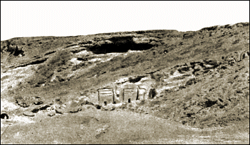 Nabatean tombs located south of al-Bad’, dating to the first century AD.
The proponents of Jebel al-Lawz might discount the objectivity of the Saudi archaeologists, but they must consider the archaeological remains. The so-called “Cave of Moses” is clearly a first-century AD Nabatean tomb. A British archaeologist who worked on the survey of those tombs explained to me how he could date them so precisely. He said the paleography of an inscription in an al-Bad’ tomb is identical with the paleography of another tomb at another site nearby. This tomb had an inscription with the name of the deceased as well as a date of his death. It is safe to say the style of those tombs is Nabatean and not earlier.
The archaeology of the so-called “altar of Moses and the 12 pillars” is also clear. I was informed by a Saudi archaeologist that the pottery is purely, and only, Nabatean. There is nothing earlier. One may debate the function of the building, but the dating is clear. It is considerably later than the Exodus.
The proponents of Jebel al-Lawz rejected a Mt. Sinai in the Sinai Peninsula because of lack of archaeological evidence. They also objected to my suggestion that one would not expect to find any because the Israelites were nomadic people dwelling in tents. A leading American archaeologist, William Dever, said, “We would still find no remains of their ephemeral camps in the desert.” He goes on to say that any attempts to make maps tracing the route of the Exodus would be “doomed to failure” (1997: 72). K. A. Kitchen, a British Egyptologist, concurs with him on the first statement when he says, “That we should find no trace of ever-moving camps in the Sinai desert is entirely correct” (1998: 107), but he goes on to chide Dever about not being able to trace the route.
The proponents also claim they have other archaeological evidence (Durham, letter to author, September 7, 2001: 2), but that their evidence awaits publication. Hopefully it will appear in a peer-reviewed archaeological journal.
I have asked a British archaeologist to review the soon-to-be-released excavation and survey report of the al-Bad’ area and Jebel al-Lawz for Bible and Spade. He is a non-Muslim archaeologist who has worked on the survey of the area, as well as an expert on Midianite and Nabatean archaeology. His approach to reviewing the excavation report for the article will include the following steps. First, he will discuss each of the archaeological sites cited by the proponents of Jebel al-Lawz. Second, he will deal with how they interpreted the archaeological data. Third, he will include what the Saudis excavated or surveyed and how they interpreted the finds. His final step will be his assessment of the different interpretations. The archaeologist will be well qualified to bring the discussion back to an archaeological debate and not a religious one, as the proponents would like to make it.
Where Was the Red Sea Crossing?
The location of the Red Sea crossing is a hotly debated topic, and I would like to throw my two cents’ worth into the debate. There are two studies that I have found to be very helpful and would highly recommend. The first is Dr. James Hoffmeier’s book Israel in Egypt (1997). While I do not agree with some of his conclusions, it is well documented and sets forth all the different views. The second study is a ThM thesis by Joel McQuitty done at Capital Bible Seminary in 1986. It is entitled, “The Location and Nature of the Red Sea Crossing.” Ironically, McQuitty wrote it at the time the proponents of Jebel al-Lawz were carrying out their adventures in Saudi Arabia! He does not interact with this view because the proponents’ view was not yet in print.
Is the location of the Red Sea crossing important for Bible believers? One commentary on the book of Exodus observes, “The exact place of Israel’s crossing of the Red Sea has no direct theological importance” (Cole 1973: 44). McQuitty points out, “In the form of the statement Mr. Cole is correct, geography normally impinges very little upon theology. However, how one determines the geography of the Bible may speak volumes concerning one’s theology” (1986: 2).
In the literature, I have been able to discern five general areas that have been proposed for the Red Sea crossing. Within each area there are several variations. I was intrigued to see in the book of one of the proponents (and it is also in their advertisement in BAR) five “proposed traditional Red Sea Crossing sites.” I have not been able to document four of these anywhere in the literature, and the proponent does not have the three usual sites above the Gulf of Suez marked (Williams 1990: map following p. 128).
The five areas that I have been able to discern, from north to south, are the following:
- The Mediterranean Sea sites. Usually the crossing is placed at Lake Sirbonis. This identification is based on placing the Baal-Zephon with a sanctuary of Zeus Casios nearby. The leading proponents of this view are O. Eissfeldt, M. Noth, H. Cazelles, Y. Aharoni, and M. Avi-Yonah.
- The northern sites. Several lakes north of the Bitter Lakes have been proposed. They are Lake Timsah, Lake Balah, or the southern extension of Lake Menzaleh. The proponents of this area are E. Naville, M. F. Unger, K. A. Kitchen, and J. Hoffmeier.
- The central site. The proponents of this view place the crossing at the Bitter Lakes. Some would suggest that the Gulf of Suez actually came up to the Bitter Lakes in antiquity. The proponents of this view are J. Simons, C. Condor, U. Cassuto, and John J. David.
- The southern view. The proponents of this view place the crossing at the northern end of the Gulf of Suez. Within this view there are two areas. One view places it just offshore from the modern-day Suez City. The other places it at a land bridge four miles south of Suez City between Ras el-‘Adabiya and Birket Misallat. The proponents of this view are E. Robinson, A. Smith, E. H. Palmer (1977: 35–37), Keil and Delitzsch, James Murphy, John Rea, J. McQuitty, and G. Franz.
- The southeastern view. This view places the crossing in the Gulf of Akaba/Eilat. Within the gulf there are two proposed crossings. One crossing, proposed by R. Wyatt and L. Moller, is a land bridge to the east of Nuweiba. The second crossing that was proposed is at a land bridge at the Strait of Tiran. R. Knuteson, J. Irwin, B. Cornuke, and L. Williams hold this view.
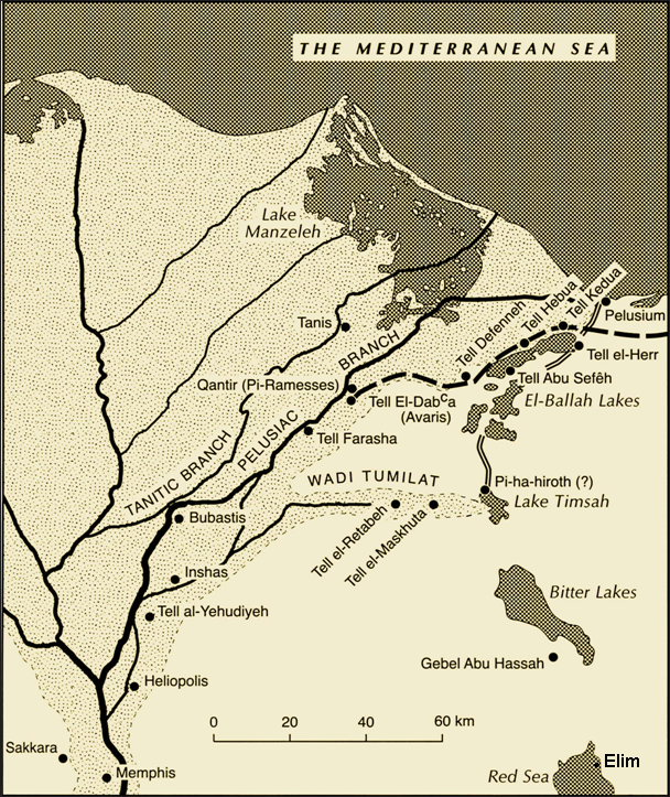 Map of the Egyptian delta including Rameses and Pi-Hahiroth.
Within the debate on the location of the Red Sea crossing there is a sub-debate on the meaning of the name Yam Suph. The common interpretation of these words today is “Reed Sea.” The first to suggest that Yam Suph means “reedy swamp” appears to be Rabbi Shelomoh Yetzhaki (Rashi) in the 11th century AD. Personally, I am not comfortable with that etymology. I will leave that discussion for another paper. I think the meaning of Yam Suph is "Red Sea."
The term Yam Suph is used 24 times in the Hebrew Scriptures (Ex 10:19, 13:18, 15:4, 15:22, 23:31; Nm 14:25, 21:4, 33:10, 33:11; Dt 1:40, 2:1, 11:4; Jos 2:10, 4:23, 24:6; Jgs 11:16; 1 Kgs 9:26; Neh 9:9; Pss 106:7, 106:9, 106:22, 136:13, 136:15; Jer 49:21). The Greek words, Erythra Thalassa, are used two times in the New Testament (Acts 7:36; Heb 11:29). These are the Greek words used to translate the Hebrew Yam Suph in the Greek Septuagint.
In the Greco-Roman world, the term Erythra Thalassa covered “all eastern waters, including the Indian Ocean; it specifically referred to the modern Red Sea and Persian Gulf” (Warmington and Salles 1996: 1296,7). Strabo, writing his Geography at the beginning of the first century AD, said, “There is another canal which empties into the Red Sea and the Arabian Gulf near the city Arsinoe, a city which some call Cleopatris [modern day Suez City GF]. It flows through the Bitter Lakes, as they are called” (17.25; LCL 8:77). Strabo makes a distinction between the Red Sea, also called the Arabian Gulf, and the Bitter Lakes. The Bitter Lakes are never called the Red Sea.
In the Hebrew Scriptures, the Yam Suph could refer to either the Gulf of Suez or the Gulf of Akaba/Eilat. The context determines the location. For example, Exodus 10:19 says, “And the LORD turned a very strong west wind, which took the locusts away and blew them into the Red Sea. There remained not one locust in all the territory of Egypt” (NKJV). As J. Rea points out, the “strong west wind” should be translated “sea wind.” In Egypt, the sea winds are from north-northwest to the south (1975: 1:572). Since the locusts covered “the face of the whole earth [land of Egypt]” (10:15; NKJV), there would need to be a large body of water to destroy the locusts. The Gulf of Suez is what is in view. Exodus 13:18, 15:4, and 15:22, and Numbers 33:10 refer to the Gulf of Suez. On the other hand, 1 Kings 9:26 says, “King Solomon also built a fleet of ships at Ezion Geber, which is near Elath on the shore of the Red Sea, in the land of Edom” (NKJV). This is clearly referring to the Gulf of Akaba/Eilat. Judges 11:16 and Jeremiah 49:20 and 49:21 are most likely referring to this gulf as well.
What are the biblical criteria for the Red Sea crossing? There are three passages that deal with the topography of the Red Sea crossing. Exodus 14:2 gives Moses's perspective. It states, “Speak to the children of Israel, that they turn and camp before Pi Hahiroth, between Migdol and the sea, opposite Baal Zephon; you shall camp before it by the sea” (NKJV). Exodus 14:9 gives Pharaoh’s perspective. It states, “So the Egyptians pursued them, all the horses and chariots of Pharaoh, his horsemen and his army, and overtook them camping by the sea beside Pi Hahiroth, before Baal Zephon” (NKJV). Of the itinerary of sites where the Israelites traveled in Numbers 33:7–8a, it is stated: “They moved from Etham and turned back to Pi Hahiroth, which is east of Baal Zephon; and they camped near Migdol. They departed from before Pi Hahiroth and passed through the midst of the sea into the wilderness” (NKJV). Three topographical sites must be identified from these passages. They are the Pi Hahiroth, the Migdol, and Baal Zephon (see Map 1).
Scholars have debated the meaning of Pi Hahiroth, but the consensus seems to be that it is a Hebraized form of Akkadian origin meaning “mouth of the canal” (Kitchen 1998: 78; Hoffmeier 1997: 169–72, 182–83, 188–89, 211, 214; Currid 1997: 134; Redford 1992: 5:371; Sneh, Weissbrod, and Perath 1975: 547; Albright 1948: 16; Skipwith 1913: 94, 95). If that is the case, what canal is being referred to? I would like to propose that there was a canal from the Bitter Lakes to the Gulf of Suez, or at least the remnants of a canal that was started and abandoned by the time of the Exodus but whose toponym was still known.
Strabo writes of such a canal. He says,
There is another canal which empties into the Red Sea and the Arabian Gulf near the city Arsinoe, a city which some call Cleopatris.…The canal was first cut by Sesostris before the Trojan War—though some say by the son of Psammitichus, who only began the work and then died—and later by Dareius the First, who succeeded to the next work done upon it. But he, too, having been persuaded by a false notion, abandoned the work when it was already near completion; for he was persuaded that the Red Sea was higher than Aegypt, and that if the intervening isthmus were cut all the way through, Aegypt would be inundated by the sea. The Ptolemaic kings, however, cut through it.… (Geography 17.1.25; LCL 8:77)
Aristotle, in his Meteorologica, states,
One of the kings tried to dig a canal to it [the Red Sea]. (For it would be of no little advantage to them if this whole region was accessible to navigation: Sesostris is said to be the first of the ancient kings to have attempted the work.) It was, however, found that the sea was higher than the land: and so Sesostris first and Dareius after him gave up digging the canal for fear the water of the river should be ruined by an admixture of sea-water. (1.14.25–30; LCL 117)
Pliny describes the planned canal between the Nile River and the Red Sea in these terms: “This project was originally conceived by Sesostris King of Egypt, and later by the Persian King Darius and then again by Ptolemy the Second, who did actually carry a trench 100 ft. broad and 30 ft. deep for a distance of 34½ miles, as far as the Bitter Springs” (Natural History 6.33.165; LCL 2:461, 2:463).
Herodotus, writing in the fifth century BC, describes the building of this canal into the Red Sea. It was begun by the Egyptian Pharaoh Necho II and finished by the Persian King Darius (The Persian Wars 2.158; LCL 1:471, 1:473). He does not, however, mention the attempt by Sesostris.
James Breasted, a noted Egyptologist, believes that Queen Hatshepsut’s expedition to Punt went down the Nile River to a canal through the Wadi Tumilat to a canal connecting to the Red Sea (1912: 188, 274–76). If he is correct, that would demonstrate that there was a canal in existence right before the Exodus from Egypt. However, several other Egyptologists have disputed this idea (Kitchen 1971: 184–207).
As Dr. Hoffmeier points out,
The possibility remains that a genuine memory of the canal-excavating accomplishments of one or more of the Sesotrises or Senuserts from Dynasty 12 may be preserved in these classical writers. The late George Posener thought these references might be connected with the work of Senusert I or III. Currently, no contemporary Egyptian texts support or deny this tradition. (1997: 169)
The classical sources seem to indicate that a canal was started by Sesostris in the 12th Dynasty (ca. 1900 BC) but not completed. If that is the case, Sesostris might have begun part of the project at the Red Sea but later abandoned it. This would have been called the "Pi Hahiroth," the “mouth of the canal.” The toponym would have been preserved even at the time of the Exodus. I would propose that the Pi Hahiroth would be located somewhere near today’s Suez City at the northern end of the Gulf of Suez.
The next toponym to consider is the "Migdol." K. A. Kitchen says that “the term migdol is simply a common noun from Northwest Semitic, for a fort or watchtower, and we do not know how many such migdols existed in the East Delta region” (1998: 78). There was a fortress at Clysma-Qolzoum (modern-day Suez City) that dates to the Late Bronze Age (Bruyere 1966). The question is, Was there an occupational level at the time of the Exodus, or was there another fortress in the area? This fortress would have guarded the northern end of the Gulf of Suez and the canal, if it existed, as well as the road coming up from the Sinai.
The next toponym to be considered is "Baal-Zephon." The identification is problematic. Dr. Hoffmeier has pointed out that the “expression literally means ‘lord of the north’ and is a deity in the Ugaritic pantheon associated with Mount Casius just north of Ugarit” (1997: 190). Eissfeldt suggested it was located at Ras Qasrun, based on the account of Herodotus (The Persian Wars 2.6, 3.5; LCL 1:281, 2:9). Baal-Zephon was worshipped at Memphis and Tell Defeneh, and a cylinder seal depicting Baal-Zephon as the “protector of sailors” was found at Tell el-Dab’a (Hoffmeier 1997: 190). W. F. Albright states that "Baal-saphôn was the marine storm-god par excellence, like Greek Poseidon. As such, he was also the protector of mariners against storms. In his honour temples were built and ports were named along the Mediterranean littoral as far as Egypt, where we find Baal-zephon worshipped at Tahpanhes (Daphne) and Memphis" (1968: 127–28). Quite possibly there would have been a temple on Jebel ‘Ataqa overlooking the northern end of the Gulf of Suez. The sailors could petition him on their way out to sea for a safe trip and thank him when they arrive safely to port.
More than likely, when the Israelites camped by the sea, it would have been on the plains at the north shore of the Gulf of Suez between Suez City and the impressive mountain to the west, Jebel ‘Ataqa. Robinson describes this area as a “desert plain…composed for the most part of hard gravel” (1977: 70). There is adequate space for the tribes of Israel.
Where would the crossing have been? Edward Robinson, in 1838, placed the crossing along the northern shore of the Gulf of Suez. He seems to favor a somewhat naturalistic explanation for a miraculous event (1977: 81–86).
Topographically, the most suitable site for the crossing is a natural land bridge that lies four miles south of the northern shore of the Gulf of Suez and that is on average 6 meters (ca. 20 feet) below the surface. This land bridge is one-half mile wide and four miles across.
With Jebel ‘Ataqa on the Israelites' right and the sea on their left and the wilderness closing in to a point at Ras el-‘Adabiya, Pharaoh’s statement in Exodus 14:3 makes sense: “For Pharaoh will say of the children of Israel, ‘They are bewildered by the land; the wilderness has closed them in‘” (NKJV).
When the Israelites saw Pharaoh and his army approaching, they were terrified and complained to Moses. Moses responded, “Do not be afraid. Stand still, and see the salvation of the LORD, which He will accomplish for you today” (Ex 14:13; NKJV). Moses lifted up his rod and the LORD divided the sea with a wall on one side and on the other as well (Ex 14:16, 14:21, 14:22, 14:29), and they went through on dry land. When they made it to the other side, the waters returned and covered the Egyptians (14:28, 15:4, 15:5, 15:19). There is no naturalistic explanation for this occurrence; it was a first-class miracle.
This location is also where the early Christian pilgrims place the Red Sea crossing (Wilkinson 1981: 100, 101, 205–207).
Once on the other side, where Birket Nisallat is today, the Israelites were in no rush to go anywhere. There was nobody chasing them anymore. The Egyptians had drowned. The Israelites probably spent the next day worshiping the Lord for His great salvation. We know that Moses composed a song and Miriam and the women danced and sang (Ex 15:1–21).
When they began their journey again, they went into the Wilderness of Shur (Ex 15:22). Edward Palmer, a 19th-century explorer, best described this scene. He said, “The word Shur in Hebrew signifies ‘a wall;’ and as we stand at ‘Ayin Musa and glance over the desert at the Jebels er Rahah and et-Tih which border the gleaming plain, we at once appreciate the fact that these long wall-like escarpments are the chief if not the only prominent characteristics of this portion of the wilderness, and we need not wonder that the Israelites should have named this memorable spot, after its most salient feature, the wilderness of Shur or the wall” (1872: 44). When I stayed in Suez City last May, I had dinner in a hotel overlooking the Suez Canal. As the sun was setting, I noticed this prominent line of escarpment as well.
The waters of Marah are a three days' journey from the Red Sea (Ex 15:22). Where these are located, I do not know for sure. The Numbers account places it in the wilderness of Etham (33:8). The Wilderness of Etham appears to be the larger area, with the Wilderness of Shur being the southern part of this wilderness. The Israelites headed north to Marah. Robinson identified a “fountain Naba” three hours' distance across the Gulf and so brackish as to be scarcely drinkable (1977: 69). The local Arabs called it el-Ghurkudeh. This was the source of the drinking water for Suez. Robinson’s Arab guide described it as “a basin eight or ten feet in diameter and six or eight feet deep, with stone steps to go down into it. In this basin the water, which is quite brackish, boils up continually and stands two or three feet deep, without any outlet; furnishing enough to supply two hundred camel-loads at once” (1977: 89). Moses cast a tree into the bitter water and it was made sweet (Ex 15:25).
Apparently after this incident the Israelites turned south to Elim with its twelve springs and 70 palm trees (Ex 15:27; Nm 33:9). A good candidate for this site is one of the most prominent springs in the Sinai Peninsula, ‘Ayun Musa. Two geologists observed that “there are twelve springs, from two which good drinking water may be obtained” (Moon and Sadek 1921: 2). In their geological report, they have pictures of this spring with palm trees in the area. When Robinson visited in 1838, he observed only seven springs (1977: 90).
The Numbers account says that they camped by the Red Sea after their time in Elim (Nm 33:10, 33:11). Somewhere at the entrance to the Wadi Sudr would be a good candidate for this campsite. Afterward, they headed up Wadi Sudr to Jebel Sin Bishar, the biblical (and real) Mt. Sinai (Har-el 1983; Faiman 2000: 115–18).
Menashe Har-el makes a solid case for Jebel Sin Bishar being the real Mt. Sinai. He points out that Jebel Sin Bishar is the only mountain in the Sinai Peninsula that preserves the toponym “Sinai” in the word “Sin” (Har-el 1983: 421). He states that “the meaning of Sin Bisher is the reporting of the Law, or Laws of man. This name hints at the Giving of the Law” (ibid.). Josephus says that Mt. Sinai is the "highest" mountain in that area (Antiquities 2.264, 3.75, 3.76; LCL 4:279, 355). While “Jebel sin Bishar is only 618 meters above sea level, it is the most prominent of its surrounding” (ibid.). Remember, Moses, at 80 years old, had to climb that mountain several times!
The Chronology from Rameses to the Red Sea
Bible geographers who deal with the Exodus take the three encampments from Rameses to the Red Sea (i.e. Succoth, Etham, and Migdol) to refer to three days of travel. The Bible does not explicitly say this.
McQuitty made an interesting suggestion back in 1986. He suggested that the seven-day Feast of Unleavened Bread commemorates the seven days it took to go from Rameses to the Red Sea (1986: 103–105; Ex 13:3, 13:4, 12:33–34; Dt 16:3; Lv 23:42–43). Ironically, one of the proponents of Jebel al-Lawz does as well. However, he goes one step further and says that the Israelites rested on the Sabbath (Durham, letter to author, September 7, 2001: 14).
If McQuitty is correct, and I believe he is, then this would fit very nicely with a crossing at the northern end of the Gulf of Suez. As K. A. Kitchen has pointed out, Rameses is located in the area of Khataana/Qantar (1998: 77). Others place Rameses at Tell el-Dab’a, another site in the area (Shea 1990: 98–111). Kitchen goes on to locate Succoth at Tell el-Maskhuta and Pithom at Tell er-Retaba (1998: 78). From the Qantar area to Suez City is approximately 100 miles. If we take that number and divide it by seven days, it comes out to about 15 miles per day. Considering the Israelites left Egypt in “haste” (Ex 12:33; Dt 16:3) and in “orderly ranks,” a military term for battle array (Ex 13:18; NKJV), 15 miles a day would be very reasonable. Robinson observed that “the usual day’s march of the best appointed armies, both in ancient and modern times, is not estimated higher than fourteen English, or twelve geographical miles, and it cannot be supposed that the Israelites with women and children and flocks, would be able to accomplish more” (1977: 75).
A near-contemporary event to the Exodus would be Thutmose III’s first campaign against the land of Canaan. Aharoni describes the march by Thutmose III and his army to Megiddo this way: “From Sile, the chief frontier post on the Egyptian border, the army covered the 150 miles to Gaza in nine or ten days, a very rapid pace” (1979: 153). In this march across the northern Sinai they encountered very sandy conditions, but they would have averaged 15 miles per day. Once they got to Canaan, they slowed down because of resistance along the way by the Canaanites (ibid., 153).
Problems with the Gulf of Akaba/Eilat Crossings
The proponents of Jebel al-Lawz do not agree on the crossing site of the Red Sea in the Gulf of Akaba/Eilat. One group, consisting of R. Wyatt, J. Pinkoski, and L. Moller, suggests that the Israelites crossed at Nuweiba. The other group, consisting of J. Irwin, R. Cornuke, L. Williams, R. Knuteson, K. Kluetz, and K. Durham, argues for the Strait of Tiran.
Regarding the Nuweiba crossing, there are several problems. The first problem is the distance it takes to go from Rameses to Nuweiba. Moller, in his video, said their route through the Sinai would take three weeks. This does not meet the biblical requirements of seven days. The second problem is the topography of the underwater land bridge. From Nuweiba the land bridge slopes down to 850 meters (2,790 feet) but then comes up sharply on the east side as it gets to the shore of Saudi Arabia. This sharp incline would make the ascent extremely difficult, if not impossible, for the Israelites to cross in one night. Dr. Roy Knuteson, a retired pastor who has done a considerable amount of research on the Red Sea crossing, also points out, “The wadi they claim the Israelites traveled on [to Nuweiba] is much to small for those millions of people” (letter to author, June 8, 2001). He goes on to say in the same letter, “The coral encrusted chariot wheels are interesting, but not convincing. The so-called ‘golden wheel’ is a fabrication.” Russell and Colin Standish have also examined the other claims of Wyatt regarding the so-called chariot wheels that were discovered (1999: 164–94).
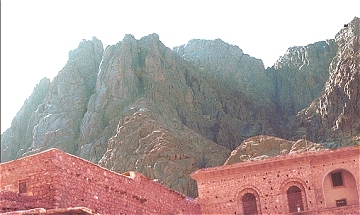 Jebel Musa in the southern Sinai, the traditional location of Mt. Sinai. St. Catherine's Monastery in the foreground.
The second crossing site, at the Strait of Tiran, has serious problems as well. The first problem is the distance from Rameses to their Red Sea crossing. From Tell el-Dab’a to Ras Nasrani at the southern end of the Sinai Peninsula is approximately 350 miles. The “Geological Photomap of Israel and the Adjacent Areas” shows that most of the way down the west side of the Sinai Peninsula is sand, alluvium, clay, marl, and sandstone. Robinson observed and wrote about the sand and gravel as he traveled south to Jebel Musa (1977: 89–96). This terrain would be difficult to travel on foot or with carts, especially when making a hasty exodus out of Egypt! This trip would be impossible to do in seven days unless they averaged 50 miles per day for seven days or 58 miles a day if they took Shabbat off. One should remember that Thutmose III’s army averaged only 15 miles per day across the sandy northern Sinai. The conditions would be very similar.
The second problem is the topography of the proposed land bridge across the Strait of Tiran. One of the proponents claims that “the distance shore to shore at the Strait of Tiran is no more than two miles by far the narrowest channel on both sides of the gulf” (Cornuke and Halbrook 2000: 215). If one measures on the nautical maps, the distance from Sinai to Saudi Arabia is eleven miles, not two.
The proponents also seem to imply that the land bridge is relatively flat and can be crossed very quickly. One proponent says, “Due north sat an oddity of Ripley’s Believe it or Not: a five-hundred-yard-wide coral reef, invisible on the surface yet spanning the entire straits like a stealth aircraft carrier” (Cornuke and Halbrook 2000: 212). He goes on to say, “The coral reef we inspected is sturdy and broad enough and situated in water shallow enough to meet this ‘dry land’ criteria. Two million Israelites, columns of cattle, flocks, fleets of carts and wagons even Egyptian troops and chariots would have been able to pass quickly over the tightly compacted coral without getting their feet wet” (Cornuke and Halbrook 2000: 214–15).
The British Admiralty map 801 and the American NOAA map 62222 show that these statements are not accurate. The shallow reefs do not go all the way across and the land bridge is not flat. In the midst of the Strait of Tiran is the Enterprise Passage (see Map 2, taken from the NOAA map 62222). This is an underwater passage/channel that goes north-south through the Strait. It is approximately three-fourths of a mile wide with a depth of 700 feet. The eastern side has a slope with at least a 60% incline. To put this incline number in perspective, in Bergen County, NJ, where I live, roads cannot have an incline of more than 10%. The 60% would be an extremely difficult, if not impossible, obstacle for travel. One of the proponents acknowledges this depth, but does not seem to grasp the significance of the problem (Cornuke and Halbrook 2000: 214). It would be a near-impossible process for two million people to go down and up these slopes, along with their carts and wagons. It would be next to impossible for the Egyptian chariots to go down and up unless they were SUV chariots with traction tires! Also, if any of them stumbled going down the slopes they would be cut very badly on the coral. This passage would be a next-to-impossible, if not an impossible, obstacle, because it would slow the pace of the Israelites down considerably or even stop it, as well as cause serious problems for the Egyptian chariots.
To illustrate the impossibility of the Strait of Tiran crossing, I would like to issue the following challenge to the proponents of this view.
The Exodus Challenge
Bob Cornuke and Larry Williams are self-proclaimed “Adventurers of History.” This challenge will be the ultimate adventure to validate their claims that Mt. Sinai is in Saudi Arabia.
|
The Challenge
Two of the three BASE participants (Bob Cornuke, Larry Williams, and Ken Durham) are to walk from Tel el-Dab'a (biblical Rameses) to their Red Sea Crossing, northeast of Sharm el-Shiek, in seven days with one day of rest for the Sabbath (either Saturday or Sunday). The Conditions They are to wear sandals and walk on the sandy ground, not on the paved road. They are to take two ten-year-old children. (Please get a parental consent form signed by both parents. I do not want you to be hauled into court for child abuse.) Also bring along two sheep and two goats. They will be permitted to buy bottled water along the way. I do not want to be responsible for their deaths by dehydration! In the event that the pillar of cloud/fire does not reappear, they will be permitted to use road maps and their good judgments as to the timing so as to cover the 350 miles, averaging 58 miles per day, in the allotted time. The Concessions They will not have to take two million men, women, or children with them, nor a herd of cattle, a flock of sheep, and a herd of goats. They will not have to bring along any nursing mothers with newborn children. They will not need to bring along senior citizens. Remember, Moses, Aaron, and Miriam were all more than 80 years old. The Promise In the unlikely event that the challengers are successful, after they have been observed by a neutral party and documented on video, I (Gordon Franz) will publicly and in print renounce my articles against the idea that Mt. Sinai is at Jebel al-Lawz and will wholeheartedly endorse their views. I will also donate $1,000 to the BASE Institute. In the likely event of failure, I will let them decide what their course of action will be. |
Ken Durham called this an “intentionally frivolous challenge” (letter to author, September 7, 2001: 7)! With all due respect, I am very serious about this challenge, because if they walk it, they will abandon the idea because they will know (experientially) that it is impossible. Durham also objected to placing Rameses at Tell el-Dab’a and would prefer to see it in eastern Goshen. As they say at Burger King, “Have it your way!” I am willing to let you start from the eastern end of the Wadi Tumilat and go the 250 miles you think was the distance.
Durham says, “A steady walking rate of 3.5 miles per hour sustained for 12 hours of navigable daylight results in a ‘days journey’ optimal linear distance of 42 miles.…Therefore, as odd as it may sound to our ears to reckon a ‘day’s journey’ as 42 to 43 miles, it is probably very close to the optimum of the Exodus Hebrews” (letter to author, September 7, 2001: 14). He then sets forth his scenario for the distance traveled each day (pp. 13–15). On the first day they travel 36 miles. The second, 36 miles and camp at Etham, but he does not identify where Etham was located. On the third day they pick up the pace to 16–18 hours per day and travel 45–48 miles. The fourth day they cover 48 miles. The fifth day they cover 40–45 miles, and the sixth day another 45–50 miles. On Shabbat they rest. If they could walk those distances each day, I would be impressed. What really stretches the imagination is Durham's reckoning of the Egyptian forces. Pharaoh had spies following the Israelites for three days. On the third day when they realize the Israelites are not stopping, they return to Pharaoh by the fourth day so he can muster his chariot force and foot soldiers in order to pursue the Israelites. Those spies would have to run back overnight to Pharaoh, covering a distance of approximately 120 miles in less than 12–16 hours (running a steady 10 miles per hour!). If Pharaoh were successful in mustering his troops in one day, they would have three days to catch up to the Israelites. They would have to average 83 miles per day, on foot and in chariots, in order to cover the 250 miles in three days! Anybody want to join them?
Other Problems with This View
It has been said, “The devil is always in the details.” There are other problems with this view. For example, the Israelites camped at Etham at the edge of the wilderness (Ex 13:20; Nm 33:6). The wilderness that is implied is the Wilderness of Etham. After they cross the Red Sea, they journey in the Wilderness of Etham again (Nm 33:8), also called the Wilderness of Shur (Ex 15:22; Robinson 1977: 80). If the proponents of Jebel al-Lawz are consistent with their views, the Wilderness of Etham would be somewhere on the west side of the Sinai, yet it would also be across the Straits of Tiran in Saudi Arabia. It does not make geographical sense to have one wilderness on the west side of Sinai and the same wilderness across the Gulf of Akaba/Eilat in Saudi Arabia.
Another problem is the Israelites’ second camp at the Red Sea. According to the Numbers itinerary, the children of Israel crossed the Red Sea, stopped at Marah, then moved on to Elim and camped by the Red Sea (Nm 33:8–11). According to the proponents of Jebel al-Lawz, Elim is located at al-Bad’ (Williams 1990: 178; Cornuke and Halbrook 2000: 96, 97, pls. 13, 14). If their view were consistent, they would have to give a reasonable explanation as to why the Israelites backtracked to the Red Sea before they proceeded to Jebel al-Lawz. On the other hand, a stop at the Red Sea, at the mouth of Wadi Sudr, on the way to Jebel Sin Bishar makes perfect geographical sense.
A third problem is the motivations of the Amalekites to attack Israel at Rephidim (Ex 17:8–16). The biblical records place the territory of the Amalekites around the area of Kadesh Barnea (Gn 14:7) and the Negev (Nm 13:29). For a discussion of the archaeology and geography of the Analekites, see Mattingly 1992: 1:169–71. If Mt. Sinai is at Jebel Sin Bishar, then the motive is clear. The Israelites are heading to the land of Canaan, and the most direct route is through Kadesh Barnea and the Negev. The Amalekites were also protecting the abundant water source at Kadesh Barnea. If Mt. Sinai is at Jebel al-Lawz, then there is no motive for the Amalekites to travel all the way down to the site to attack the Israelites. If the Israelites were going to the land of Canaan, they could go up the Transjordanian Highway and avoid Kadesh Barnea and the Negev altogether. Some proponents of Mt. Sinai being in Midian place Kadesh Barnea in the area of Petra. I have repeatedly asked the proponents of Jebel al-Lawz where they place Kadesh Barnea and they have yet to give me an answer.
The Conclusion of the Matter
As popular as the idea that Mt. Sinai is at Jebel al-Lawz in Saudi Arabia may be in certain evangelical (and even Jewish) circles, there is no credible historical, geographical, archaeological, or biblical evidence for this thesis.
There are several unsubstantiated claims that the proponents of this site need to substantiate or abandon. First, the Sinai Peninsula was not part of Egypt proper, but “out of Egypt.” Second, biblically, Mt. Sinai is not in the land of Midian, yet Jebel al-Lawz is in Midian territory (northwest Saudi Arabia). Third, the Sinai Peninsula was part of “Arabia” in the first century AD. Paul would be perfectly correct in stating that Mt. Sinai is in Arabia if Mt. Sinai was at Jebel Sin Bishar.
The proponents also need to face up to the archaeological evidence at their site. The petroglyphs of bovines existed long before Moses ever lived. The so-called “Cave of Moses” at al-Bad’ was not hewn until long after Moses lived. The so-called “altar of Moses and the 12 columns” dates to the Nabatean period and has nothing to do with the wilderness wanderings.
The Red Sea crossings at the Gulf of Akaba/Eilat have serious topographical and biblical/geographical difficulties that the proponents of the view need to consider.
A more plausible location for Mt. Sinai is at Jebel Sin Bishar in west central Sinai. If that is the case, the Red Sea crossing would best be located at a natural land bridge that goes east-west across the northern Gulf of Suez to the east of Jebel ‘Ataqa. The Pi Hahiroth, the “mouth of the canal,” would be the remnant of an unfinished canal near the modern day Suez City. The Migdol, “fortress,” would be at or near Clysma. Baal-Zephon would be a temple to the mariner storm god Baal somewhere on Jebel ‘Ataqa.
Had the proponents of Jebel al-Lawz examined the evidence in the libraries in the United States carefully and visited the Egyptian Museum in Cairo, they would have come to a different conclusion. First of all, they would have discovered that they were looking in the wrong place for the Red Sea crossing and Mt. Sinai. Second, in the Cairo Museum they would have noticed the chariots of Pharaoh Tutankhamen. With the exception of Pharaoh’s gold-plated chariot, all the other chariots were made of wood and rawhide (leather), with a few copper components. The first two items would have disintegrated quickly underwater (Littauer and Crouwel 1992: 1:888.889). Thus there would be nothing left of the chariots to discover with the exception of a few pieces of copper.
Finally, the proponents would have considered the words of Josephus. “On the morrow, the arms of the Egyptians having been carried up to the Hebrews’ camp by the tide and the force of the wind setting in that direction, Moses, surmising that this too was due to the providence of God, to ensure that even in weapons they should not be wanting, collected them and, having accoutred [equipped] the Hebrews therein, led them forward for Mount Sinai, with intent there to sacrifice to God and to render to Him the thank-offerings of the people for their deliverance, even as he had received commandment” (Antiquities 2.349; LCL 4:317, 4:319). Why look for things that had disintegrated long ago and weapons that were providentially given to the Israelites? It would be better to follow the example of Moses and go and worship the Lord for His great salvation!
Recommended Resource for Further Study
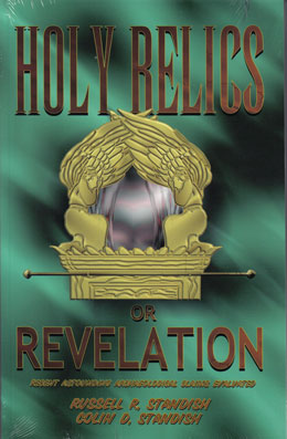 Biblical archaeologists have gathered archaeological data with painstaking effort and scholarship. Their work validates the accuracy of the Bible. Yet, mostly within a single decade, Ron Wyatt sought out and claimed the most amazing biblical sites and relics. The sensational discoveries claimed by Wyatt number nearly 100 and include such things as the ark of the covenant, anchor stones from Noah's ark, a book of the law written by Moses, and the original Ten Commandments in stone. Also included are Christ's literal living blood, fences from Noah's farm, the golden censer, Goliath's sword, the graves of Korah and friends, the table of showbread, and the wheels of Pharaoh's chariots (Standish: 7–10). These are only the beginning. It is unfortunate for those who love the Bible that all of these incredible claims are almost certainly fraudulent. A great criticism leveled at Wyatt has been that his "evidence" has generally been in the form of either photographs or nonconclusive specimens, which may or may not have come from the sources he claims. His "findings" have not been given independent confirmation by other researchers with specialized training in the fields of archaeology and related sciences, which Mr. Wyatt (a nurse anesthetist by profession) did not have (he died in 1999). This lack of specific education by itself would not invalidate his findings if they could be supported by others, but they cannot. In this book, the Standish brothers examine the Wyatt claims in depth, going beyond his videotaped claims. These findings can serve as a benchmark upon which Ron Wyatt's "discoveries" can be more carefully evaluated. In 58 easy-to-read chapters, the Standish brothers meticulously, painstakingly examine in detail all of Wyatt's claims.