This article was first published in the February 2007 ABR Electronic Newsletter.
Spending a month excavating in the Jordan Valley at Tall el-Hammam last winter caused me to rethink some of what I thought I knew about the region. Since this dig will continue for a number of years, I decided a better understanding of the geology, geography and ecology of the area would help me better interpret our archaeological data. So here is some of what we know about the ecosystem surrounding Tall el-Hammam for the past 5,000 years.
The Jordan River Valley stretches 65 miles from the Sea of Galilee to the Dead Sea, all below sea level. Enclosing the valley’s entire length are the western mountains of Judah and Samaria and the eastern Jordan plateau. Rising to over 3,900 ft, these mountains keep the valley’s temperature mild, even during the rainy winter season (Ibrahim 1992: 958). Relatively flat, the floor of the Jordan Valley stretches from 2 miles wide in the north to 11 miles wide where it empties into the Dead Sea, near Tall el-Hammam (Ibrahim 1997: 248). Referred to locally as the ghor (Arabic “bottom” or “depression”), most of the flat Jordan Valley has been cultivated throughout history.
The Jordan River Valley, itself, is an extension of the major earthquake fault line known as the Great African Rift Valley that runs through the Red Sea’s eastern finger (the Gulf of Aqaba) and Arabah to the Dead Sea. Continuing through the Jordan Valley, Sea of Galilee and the Hulah Valley, it finally ends in Lebanon’s Beqah Valley (Thompson 1992a: 956). As part of this great fault line, the Jordan River Valley has experienced numerous earthquakes, many during the Biblical period.
Within the ghor of the Jordan Valley is a secondary valley, another 100–200 feet deeper, called the zor (Arabic “thicket”). This name points to the luxuriant green tropical growth through which the Jordan River twists and turns its way south. Calling it the “jungle of the Jordan,” Glueck (1946: 63) noted that while the vegetation looks attractively green, it is composed of rank varieties of thorns and thistles growing shoulder high. This is the Jordan’s river bed and it has constantly changed its course down through history. Maybe a mile wide in antiquity, the zor is greatly diminished today, only 0.6 miles at its widest.
The zor is probably what the Old Testament referred to as ga’on hayyarden. From the verb g’h (Hebrew “to rise up”), it suggests the nouns “pride” or “swelling.” Thus the KJV translated it: the “swelling of the Jordan” (Jer 12:5; 49:19; 50:44) and “pride of the Jordan” (Zech 11:3). The thought of the translators seemed to have been the river’s springtime flooding of its banks.
Yet, knowing the geography and ecology of the region, and following the Arabic zor (“thicket”), the Jewish Publication Society translated each passage as the “jungle of the Jordan.” The NIV translated it as “thickets of the Jordan” (while offering a note at each reference suggesting the alternate meaning of “flooding”). I agree with Thompson’s (1992b: 960–61) summary that “jungle” or “thicket” is probably the best understanding of the writer’s original meaning.
The boundary between the ghor and the zor is also a very distinctive feature. Here, stretching for a few hundred yards on both sides of the zor, are uniquely shaped eroded marl hills. Basically rounded by flowing flood waters through the centuries, these hills, called the katar (Arabic), are barren and generally uncultivable (Thompson 1992: 955).
Flowing within the zor’s full 65-mile length is the Jordan River, actually twisting and turning for a total of 135 miles. Both deeper and wider in antiquity (Thompson 1992: 956), under normal conditions today the Jordan is never more than 100 feet wide (and generally only a fraction of that) and less than 10 feet deep, due to the diversion by both Israel and Jordan of water that once flowed into it. But with springtime rains, the river can still overflow its banks, spilling out of the zor (“the jungle of the Jordan”) and onto the ghor (the Jordan River Valley).
While it is unclear if the Jordan was ever really navigable (Thompson 1992a: 958), the river and zor did provide an appropriate habitat for a surprisingly wide variety of wild animals in antiquity. Archaeological remains from some of the Jordan Valley’s earliest sites suggest the region was once home to elephants, lions, hippopotami, rhinoceroses, leopards, boars, ibexes and alligators (Thompson 1992a: 955–56).
One of the reasons that the Jordan is not seen as navigable is the lack of evidence for any major settlements within the zor or the katar in antiquity. This would be due to the river’s annual flooding and its continually changing river bed (Ibraham 1997: 248). Because of the rain-shadow effect, which causes very minimal rain on the Judean and Samarian hills’ eastern slopes, there are fewer tributaries feeding into the Jordan River from the west. The same phenomenon provides only minimal rainfall in the Jordan Valley, itself, but produces significant rainfall on the Jordanian hills, creating numerous tributaries flowing into the Jordan from the east. This abundance of runoff rain water from the Jordanian hills helps explain the far greater number of ancient settlements on the valley’s east side (Thompson 1992a: 957). In the area of Tall el-Hammam three such rivers flowed from the Jordanian highlands: the Nimrin (Shu’eib), Kefrein and Rameh (Hisban). Glueck (1946: 73) noted this was the area Lot viewed from Bethel-Ai in the Judean hills that was described “like the garden of God” (Gn 13:10).
In the location where these tributaries empty into the Jordan River, ancient fords were built up from deposited silt. Archaeological evidence suggests three such fords crossed the Jordan near Tall el-Hammam. The southern-most and probably main Jordan River ford at Makhdat (Arabic ‘ford) Hajla (preserving the Biblical name of Beth-hoglah) and a second ford to the north at el Ghoraniya (almost due east of Jericho) both had roads to Jericho. A third, the northern-most ford, at Makhdat Mindisa apparently did not connect directly with Jericho (Dorsey 1991: 202, 205). It is unclear how the ancients crossed the river, although they may have utilized boat and rope ferries as seen on the sixth century AD Madaba Map in this very area. Such ferries are a common sight crossing canals in Egypt still today. But the Jordan’s swiftness may have rendered such a system unworkable. As far as we know, the Romans were the first to bridge the river (Thompson 1992a: 956–57).
The southern section of the Jordan Valley floor, where Tall el-Hammam is situated, is the valley’s widest point. Called the kikkar hayyarden (Hebrew “kikkar of the Jordan”) in Genesis, Glueck (1946: 72) translated it as the “encircled Jordan Valley.” The Tall el-Hammam Excavation Project (TeHEP) calls it the “Jordan disk,” because here the flat River Valley widens into a circular appearance when viewed from above. This is the same region later called the arabah (“plains”) of Moab’ in Numbers and Deuteronomy.
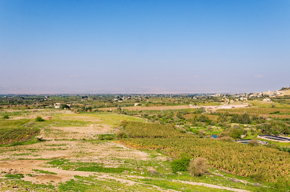 View of the plains of Moab from Tall el-Hammam. Credit: Todd Bolen / BiblePlaces.com.
Throughout history, habitation in the Jordan Valley has been a challenge. Settlers have to consider the availability of water, arable land, security and a road system, as well as annual floods and periodic earthquakes. Tall el-Hammam was settled next to a hot spring (Arabic hammam), along one of the tributary rivers from the east (the Kefrein), adjacent to arable land and near the major north-south highway. But its location on the far eastern edge of the kikkar kept it away from floods and earthquakes.
Standing on the edge of the Tall each morning of the excavation and looking over the Jordan Valley, I wondered if I was standing in the very spot where Moses and the Israelites camped before entering Canaan. Behind me was Mount Nebo where Moses was buried and before me was the location of Israel’s Jordan River crossing. I was within eyesight of both Elijah’s translation to heaven in a whirlwind and John’s baptism of Jesus. In the distance was the mound of the first city the Israelites captured in Canaan—Jericho. Here in the eastern Jordan River Valley, I was truly standing in the midst of the Holy Land.
Bibliography
Dorsey, David A. 1991. The Roads and Highways of Ancient Israel. Baltimore: Johns Hopkins.
Glueck, Nelson. 1946. The River Jordan. Philadelphia: Jewish Publication Society.
Ibrahim, Moawiyah M. 1992. “Jordan Valley.” Pp. 958–60 in The Anchor Bible Dictionary 3, ed. David N. Freedman. New York: Doubleday.
———. 1997. “Jordan Valley.” Pp. 248–51 in The Oxford Encyclopedia of Archaeology in the Near East 3, ed. Eric M. Myers. New York: Oxford.
Thompson, Henry O. 1992a. “Jordan River.” Pp. 953–58 in The Anchor Bible Dictionary 3, ed. David N. Freedman. New York: Doubleday.
———. 1992b. “Jordan, Jungle of.” Pp. 960–61 in The Anchor Bible Dictionary 3, ed. David N. Freedman. New York: Doubleday.