| This article was first published in the Winter 2006 issue of Bible and Spade. |  |
Introduction
It may come as a surprise to many students of the Bible that in the original Hebrew text the body of water the Israelites crossed when leaving Egypt is called yam suph, “Sea of Reeds,” not Red Sea (Ex 15:4, 22; Dt 11:4; Jos 2:10; 4:23; 24:6; Neh 9:9; Ps 106:7, 9, 33; 136:13, 15). Unfortunately, yam suph has been rendered “Red Sea” in nearly all of our translations, the Jerusalem Bible and the New Jewish Publication Society Hebrew Bible being notable exceptions.
The “Red Sea” phrase came into the account with the third century BC translation of the Old Testament into Greek. Called the Septuagint (abbreviated as LXX), its translators made yam suph (“Sea of Reeds”) into eruthrá thálassē (“Red Sea”). The Latin Vulgate followed their lead with mari Rubro (“Red Sea”) and most English versions continued that tradition.
Unfortunately, “Red Sea” was not a translation at all, and the LXX translators understood that. While we do not know their reasoning, they gave yam suph a historicized interpretation, based on their understanding of the region at the time (Kitchen 2003: 262; Hoffmeier 1996: 206; 2005: 81). When the Bible indicated the Israelites crossed a significant body of water on Egypt’s eastern border, the LXX translators connected it with the body of water they knew as the Red Sea. Instead of translating the Hebrew phrase literally, they offered this historical identification as their interpretation of the text.
I suggest this is an unfortunate translation that has confused the issue for centuries and has kept us from appreciating the real historical accuracy of the Exodus and sea crossing accounts. In the late 20th century, scholars began to reestablish the meaning of the Hebrew text to its Egyptian context in a fresh way and then connect it with recent archaeological evidence (see Hoffmeier 2005: 81–85).
The Red Sea
But, you ask, what about the Red Sea? The Red Sea includes two fingers of Indian Ocean salt water that extend northward into the Biblical world and help separate the two continents of Africa and Asia. The Red Sea’s eastern branch is known as the Gulf of Aqaba (Arabic) or Gulf of Elat (Hebrew), and the western branch is known as the Gulf of Suez (Arabic, and the origin of the name of the Suez Canal which connects this western branch to the Mediterranean Sea).
In classical Greek, the name Red Sea was used for both gulfs as well as the main body of the Red Sea, the Persian Gulf and the Indian Ocean (Kitchen 2003: 262–63; Hoffmeier 1997: 200). Unfortunately, today we do not know why these bodies of water were originally called “Red Sea” (Hoffmeier 1997: 206).
One interesting suggestion has a Biblical basis. Maybe the Red Sea received its name from the Edomites, perennial Old Testament enemies of the Israelites. The Edomites, whose name means “red” in Hebrew, controlled the Gulf of Aqaba during much of the Old Testament period. It has been suggested that later Israelites had difficulty referring to this sea by the name of their enemy (that is, the Edomite Sea), so they used the meaning of Edom (“red,” Greek eruthrá) instead to identify it (Hoffmeier 1997: 206).
Another possibility is that the Gulf of Suez was already known as the Red Sea (for a presently unknown reason), and its application to the Gulf of Aqaba was a natural extension (Hoffmeier 1997: 206). Whatever the origin of the term, it was not the name of the body of water the Bible says the Israelites crossed in the Exodus.
To complicate matters more, the New Testament follows the LXX in referring to the location of the Exodus sea crossing as the “Red Sea.” While a full treatment of the New Testament references is beyond the scope of this article, I will suggest that our understanding of ancient Egypt’s eastern frontier and the terminologies describing it are still incomplete and that the present state of our research is like working a puzzle with a number of key pieces still missing.
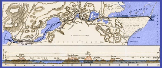 der Suezkanal, by Albert Ungard edler von Öthalom, taf. IV (Vienna: A. Hartleben’s, 1905)Route of the Suez Canal. The famous Canal is one of the greatest engineering feats of modern times, providing a major shipping route between Europe and Asia. The pilot study estimated that a total of 2,613 million cubic feet of earth would have to be moved, including 600 million on land, and another 2,013 million dredged from water. The total original cost estimate was two hundred million francs. The canal stretches over 100 mi (160 km) from Port Said on the Mediterranean Sea to Suez on the Red Sea. The first efforts to build a modern canal came from the Egypt Expedition of Napoleon Bonaparte, who hoped the project would give France a trade adavantage over England. Though it was begun in 1799 by Charles Le Pere, a miscalculation estimated that there was a 33 ft (10 m) difference in level between the Mediterranean Sea and the Red Sea and work was suspended. When it was later determined that there was no difference between the two seas, the French consul to Egypt, Ferdinand de Lesseps, had the vision and perseverance to bring the project to completion. Work began in 1859 and, after a number of setbacks and delays, was completed a decade later, thus physically severing Africa from Asia. The Suez Canal emerged on the political scene in 1956, during the Suez crisis brought about when Egyptian president Nasser announced the nationalization of the Canal. His decision was in response to the British, French and American refusal for a loan to build the Aswan high dam. The revenue from the Canal, he argued, would help finance the High Dam project. The announcement triggered a swift reaction by England, France and Israel, who all invaded Egypt. Their action was condemned by the International community and the canal was turned over to Egypt. In 1967, the Canal was closed as a result of the Six-Day War, when Israel occupied the Sinai Peninsula. The canal was reopened in 1975 following the 1973 Arab-Israeli War. The Canal has been widened twice since the reopening. Called the crossroads of Europe, Asia and Africa, approximately 50 ships cross the canal daily, taking from 11 to 16 hours to make the journey. A little known fact about New York’s Statue of Liberty is that it was originally to have stood at the entrance to the Suez Canal in Port Said. Inspired by the colossal statues of Rameses II at Abu Simbel, French sculptor Frederic Auguste Bartholdi came up with the idea of a huge statue of a woman bearing a torch. She was to represent progress—“Egypt carrying the light of Asia,” according to Bartholdi. However, Egypt’s leader, khedive Ismail, decided the project was too expensive and replaced it with a more modest statue of Ferdinand de Lesseps. Bartholdi took his plans to the US and promoted the concept of a colossal female statue dedicated to “Liberty Enlightening the World” in New York harbor. He was commissioned to undertake the work and funds were raised on both sides of the Atlantic. In the end, the statue became a gift of international friendship from the people of France to the people of the United States. And so, “Canal Lady” became “Lady Liberty.”
Sea of Reeds
There is general agreement among scholars today, both liberal and conservative, that yam suph means “Reed Sea.” The Hebrew suph definitely referred to a water plant of some sort (Kitchen 2003: 262), as indicated in Exodus 2:3–5 and Isaiah 19:6–7, where reeds in the Nile River are mentioned (Hoffmeier 2005: 81). In fact, it is probable that the Hebrew suph (“reed”) is an Egyptian loan word—from the hieroglyph for water plants (twf) (Huddlestun 1992: 636; Hoffmeier 1997: 204; 2005: 81–83).
Unfortunately, a more precise identification to a specific water plant for suph is not presently possible. Still, the Bible is clear that the sea the Israelites crossed was the “Reed Sea.” This suggests a large body of water on Egypt’s eastern border that is identified with reeds. But where was it located? In the Bible, the name yam suph is used in reference to the Gulf of Aqaba (Ex 23:31; Nm 21:4; Dt 1:40, 2:1; 1 Kgs 9:26) and apparently the Gulf of Suez (Nm 33:10–11). That makes both legitimate candidates for the sea crossing location.
While few scholars have posited the Reed Sea crossing point to be on the eastern Gulf of Aqaba, Robert Cornuke and Larry Williams have recently popularized that idea (Blum 1998). However, that location appears to be too far east of Goshen to fit the literal understanding of the Exodus itinerary (Hoffmeier 2005: 130–40; Franz 2000; Wood 2000).
On the other hand, the popular view among conservative scholars has been to locate the Exodus crossing somewhere along the northern tip of the western Gulf of Suez. Unfortunately, the place names in the Exodus account do not fit that region very well. Neither has modern archaeological research added any support to this location for the Exodus sea crossing.
Whether one chooses either gulf, the important issue is that the location was the yam suph. If the Gulf of Suez is chosen as the Exodus crossing site, the location must be based on Biblical and extra-Biblical data. The Gulf of Suez must not be chosen because it is called the Red Sea today, or even in antiquity. I propose that a literal and careful understanding of the Biblical text, in conjunction with the most recent research from the eastern Nile delta, suggests a location other than the Gulf of Suez.
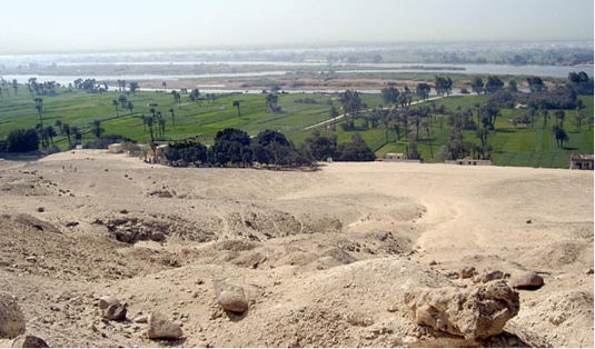
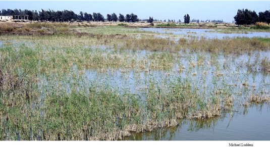 Reeds in the vicinity of Tell Defenneh. While creation of the Suez Canal in the 19th century permanently changed the Isthmus of Suez, reeds still grow in some of the region’s marshy areas. This photo was taken in the area of the ancient Ballah Lake system, just a few miles west of the Suez Canal. The author suggests it was in this lake area that recent geological and archaeological research best demonstrates the place names mentioned in the Exodus sea crossing.
Suez Isthmus
The land area north of the Gulf of Suez, all the way to the Mediterranean coast, is known today as the Isthmus of Suez. It includes the eastern Nile delta (where Goshen was located, east of the Nile’s Pelusiac branch; see Kitchen 2003: 254, 261), the marshy lakes to the east, and the desert beyond. In antiquity there were five lakes in this narrow strip of land: Ballah Lake, Lake Timsah, Great Bitter Lake and Little Bitter Lake.
This entire area, from the northern limit of the Gulf of Suez to the Mediterranean coastline, is not at all as it was in antiquity. Evidence suggests that the Gulf of Suez extended further north in antiquity than it does today, although we do not presently know how far north (Hoffmeier 1997: 209). Also, the Mediterranean coastline during the second millennium BC was much further south than it is today (Scolnic 2004: 96–97; Hoffmeier 2005: 41–42), so the isthmus between the two was much narrower than today. What has remained consistent about the region throughout history is the fact that it has always been known for marshy freshwater lakes. Consequently, it should be of no surprise that the Suez Canal was cut directly through here in 1869.
Egyptian texts use the hieroglyph for “reed” (twf) in reference to this region, suggesting they were prominent there (Huddlestun 1992: 636–37) and that the name was associated with that area (Hoffmeier 2005: 81–83). In fact, Hoffmeier, in agreement with Manfred Bietak, excavator of Rameses (see Wood 2004), has concluded that the hieroglyphic term p3 twfy (p3 being the definite article “the”) referred specifically to a particular reedy lake on Egypt’s eastern border—Ballah Lake (2005: 88).
Noting Bietak’s important paleoenvironmental study of the region, Hoffmeier added that Tell Abu Sefeh, at modern Qantara East on the west side of the present Ballah Lake area, probably reflects the ancient Egyptian name for that lake (p3 twfy) and its Hebrew counterpart (yam suph) (2005: 88–89). Hoffmeier also points out that excavations at Tell Abu Sefeh have uncovered remains of an impressive harbor with quays that once handled multiple trading vessels (2005: 88). While archaeological evidence has identified remains later than the Exodus period, it is obvious that the Ballah Lake was once a substantial body of water on Egypt’s eastern border.
Kitchen suggested that the Reed Sea terminology might have been used by the ancients for all the bodies of water in the series of reedy lakes that ran the full north-south length of the isthmus (2003:262). By extension, it was also applied to the last of these bodies of water—the Gulf of Suez. This would also explain Numbers 33:10, where the Israelites again passed yam suph (so-called “yam suph II” [Kitchen 2003: 271]) later in the Exodus narrative, after the miraculous yam suph crossing earlier. Maybe at that time, or even later, the same term also came to be used for still another “connected” body of water—the Gulf of Aqaba.
Geological studies indicate that natural factors have produced great changes in both the Nile delta and Isthmus of Suez through the millennia. More recent human activity has changed the region most of all. Completion of both the old (1902) and new (1970) Nile River dams at Aswan have dramatically affected the river’s flow and greatly reduced its flooding. With the Nile flooding non-existent, the perennial flood safety valve—the Wadi Tumilat, running from the Nile to the Isthmus of Suez lakes—no longer served that need (Hoffmeier 1997: 207). An even greater impact on the isthmus lakes came from construction of the Suez Canal, completed in 1869. It drained much of the marshy area of the Ballah Lake (Hoffmeier 1997: 211; 2005: 43).
Beyond the combined impact on the isthmus of these modern construction projects, the water level of the Gulf of Suez is presently lower than in antiquity. Apparently due to natural causes unrelated to either the Nile River dam or the Suez Canal, the Gulf of Suez is lower today and does not extend as far north into the isthmus as it once did (Hoffmeier 1997: 207–208).
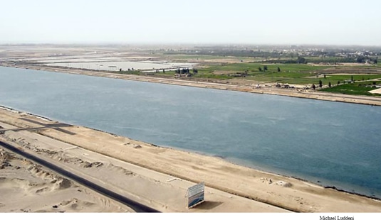 View of the Suez Canal looking south from Qantara. The Suez Canal extends 105 mi (170 km) from Port Said on the Mediterranean Sea to Suez City at the northern end of the Gulf of Suez. From here, ships have direct access to the Pacific Ocean. The Canal, originally 26 ft (8 m) deep, 177 ft (54 m) wide across the top and 72 ft (22 m) wide at the bottom, is much deeper and wider today to accommodate modern ships. Completion of the Canal in 1869 permanently altered the ancient lake region north of the Gulf of Suez. Amazingly, canals cut in the same region by ancient Egyptians were of similar dimensions as the original Suez Canal. The area seen in the photo is where the northern end of the ancient Ballah Lake was formerly located. This is the most likely local for the sea crossing according to recent research.
Eastern Frontier Canal
For millennia man has desired to impact the Suez Isthmus region, but with minimal success. Ancient Egyptian texts and modern geological surveys have identified ancient canal lines cut between the marshy lakes in antiquity, called the Eastern Frontier Canal by their discoverers (Hoffmeier 2005: 42). Long before the Suez Canal, both native and foreign rulers cut canals through the Isthmus for a variety of reasons. Ancient documents mention canal construction by Pharaohs Sesostris I or III (12th Dynasty), Necho II (610–595 BC) and the Persian king Darius (522–486 BC), as well as Ptolemy II (282–246 BC) (Hoffmeier 1997: 165, 169).
Thus it was not surprising that geologists found evidence of a man-made canal joining the lakes in the northern sector of the isthmus. Probably cut for defensive purposes as well as for irrigation and navigation, it created a formidable eastern border barrier. Known portions of this canal are consistently 230 ft (70 m) wide at the top, an estimated 66 ft (20 m) wide at the bottom and 6.5 to 10 ft (2–3 m) deep. This ancient canal was wider than the original Suez Canal, 177 ft (54 m) across the top and 72 ft (22 m) at the bottom.
While no one is suggesting that the Israelites crossed a canal, it was apparently an important feature in Egypt’s eastern border defense designed to make travel difficult. The adjacent embankments created by digging this canal would have added to the formidability of this border defensive system (Hoffmeier 1997: 170–71; Kitchen 2003: 260).
Thus, crossing the sea in this region represented a true departure from Egypt. West of the lake-and-canal border was the cultivated land of the delta, with Goshen located on the eastern side, but still very much part of Egypt. East of the lakes was the desert where the Israelites would no longer be within Egypt proper (Hoffmeier 2005: 37, 43). Anyone who has visited Egypt can’t help but be struck by the stark contrast of green, cultivated Nile delta and the brown barren desert, in places just yards apart.
 Contrast between the desert and the sown. The cultivated Nile River valley (550 mi [900 km] from the southern border of Egypt to the delta) and the cultivated delta (stretching up to 150 mi [240 km] east to west along the Mediterranean coast) with the arid desert on both the east and west is striking. Throughout history Egyptians lived almost exclusively along the cultivated river valley and delta. Yet, anywhere irrigation is practiced in the desert, the soil is fertile. This photo was taken from the Middle Kingdom tombs at Bene Hasan, about 165 mi (265 km) south of Cairo.
Wadi Tumilat
During prehistoric times (before 3200 BC), the Nile’s easternmost branch once passed through the Wadi Tumilat. Stretching 31 mi (52 km) from just west of modern Zagazig (ancient Bubastis) to Ismailiya (on Lake Timsah), it created a portion of the eastern edge of the Nile delta. While the course of this delta branch disappeared in historic times, and the present eastern branch is significantly further to the west, both historical and archaeological evidence indicate that ancient canals were cut from the Nile River eastward through the Wadi Tumilat (Hoffmeier 1997: 165; 2005: 41).
This ancient watercourse apparently continued to flood periodically throughout history with the overflow of the Nile’s annual flooding (Hoffmeier 1997: 165; 2005: 43). Thus, the Wadi Tumilat may have been one of the reasons that the Isthmus of Suez became known for its marshy fresh water lakes and associated “reeds” (twf). The Wadi Tumilat was no doubt part of the Biblical Land of Goshen. It is within this very area of the Isthmus of Suez that topographical and archaeological research locates the initial sites mentioned in the Exodus itinerary.
The valley’s very name today even hints at its place in the Exodus. The Arabic term “Tumilat” actually preserves the name of the Egyptian god Atum (Hoffmeier 2005: 62, 64, 69), and it would appear he was well respected in this region during the time of the Exodus. The store city of Pithom (Ex 1:11) is the Hebrew name for a site that would have been known in Egypt as pr-itm (“house [or temple] of Atum”) and it was probably located in the ancient Wadi Tumilat (Hoffmeier 2005: 58–59). In addition, the Exodus itinerary site of Etham was no doubt named after the same Egyptian deity (Hoffmeier 2005: 69).
The region’s geography and the Exodus account fit together. The Israelites departed from Rameses to the north of Wadi Tumilat and headed south after the last plague (see Ex 13:17–14:3). They came to Succoth in the Wadi Tumilat then headed east to Etham in the vicinity of Lake Timsah. Turning north, they were overtaken by the pursuing Egyptians at Pi Hahiroth, between Migdol and the sea and before Baal Zephon (Ex 14:2).
This was all still the green, cultivated area of the Nile delta—still Egypt proper. The Israelites were facing an impregnable border between them and freedom in the Sinai—the freshwater lakes with their interconnecting canals and a series of strategically located forts. It appeared to them and to Pharaoh that they had no place to go (Ex 14:3, 11–12).
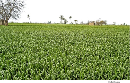 Agricultural fields in the eastern delta in the area of Qantir, ancient Rameses. The Nile delta has been created by the continuous flow over the millennium of the Nile River from Lake Victoria in the south to the Mediterranean Sea. Every few centuries the flows of various Nile delta branches migrate and create new paths to the sea, as well as additional cultivatable delta land at the edge of the Mediterranean. It was in the eastern delta where the Israelites lived in Goshen.
Horus Way
There were three ancient main roads that left the Nile delta going east. One was a mining road from the southern delta near Memphis to the northern tip of the Gulf of Suez. A second exited from the eastern end of the Wadi Tumilat toward the Negev and the third was the international coastal highway (Shea 1990: 103–107; Kitchen 2003: 266–268; Hoffmeier 1996:181, 187–188; see Scolnic 2004: 95, fig.1).
The Bible is very clear that the Israelites lived in Rameses from the beginning of the Sojourn (Gn 47:11) to the Exodus (Ex 12:37). It was also the starting point for Egypt’s direct road to Canaan, a northern route running along the ancient Mediterranean coastline. Also Egypt’s military highway to the east, there were 23 fortresses garrisoned with Egyptians troops at intervals along the way. The westernmost segment of the international highway, it was called the Horus Way by the Egyptians and “the road through the Philistine country” in the Bible (Ex 13:17). While the international highway is commonly known as the Via Maris (Latin, “Way of the Sea”), recent research has demonstrated this is a modern name, not an ancient one (Beitzel 1991).
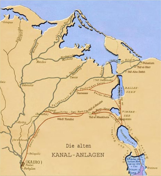 der Suezkanal, by Albert Ungard edler von Öthalom, taf. I (Vienna: A. Hartleben’s, 1905). Ancient canals in the eastern delta. From early antiquity there has been interest in a link between the Mediterranean and Red Seas. Most of the early efforts were directed towards a link from the Nile to the Red Sea. Strabo and Pliny record that the earliest effort was directed by Sesostris I or III (12th Dynasty). Under Necho II (610-595 BC) a canal was built between the Pelusiac branch of the Nile and the northern end of the Bitter Lakes at a reported cost of 100,000 lives. Over many years, the canal fell into disrepair, only to be extended, abandoned, and rebuilt again. After having been neglected, it was rebuilt by the Persian ruler Darius I (522–486 BC), whose canal can still be seen along the Wadi Tumilat. It was extended to the Red Sea by Ptolemy II Philadelphus (282–246 BC), abandoned during the early Roman rule, but rebuilt again by Trajan (AD 98–117). Over the next several centuries, it once again was abandoned and sometimes dredged by various rulers for various, but limited, purposes. Amr Ibn el-As rebuilt the canal after the Islamic takeover of Egypt creating a new supply line from Cairo, but in AD 767 the Abbasid caliph El-Mansur closed the canal a final time to cut off supplies to insurgents located in the delta.
The Horus Way is pictured in relief by Pharaoh Seti I at the Karnak Temple of Amun, with eleven forts and even a waterway. With the waterway depicted vertically through the relief and Pharaoh Seti moving horizontally along the Horus Way, it can be assumed that the waterway is running north-south as the international highway heads east to Canaan. The waterway is labeled ta-denit, which means “the dividing waters.” While that name does not clarify if it is a canal or marshy lake, the very title and its north-south orientation suggest it is the border between the Nile delta (Egypt proper) and the desert to the east. Depicted as lined with reeds, it appears to at least be associated with a marshy lake (Hoffmeier 1996: 166–167).
Sitting along the Horus Road and adjacent to the waterway is a site identified as Tjaru, a large town and important fortress on Egypt’s eastern border. While structures appear on both sides of the waterway, the name is on the desert side, an appropriate location to secure Egypt’s border. From Seti’s Karnak relief and the Egyptian text Papyrus Anastasi I, Gardiner identified 23 fortifications along the Horus Road, beginning with the border fort at Tjaru and ending with a fortress at Raphia in southern Canaan (Hoffmeier 1996: 183; 2004: 61; 2005: 41). In recent years geological and archaeological research in the North Sinai region have begun to identify many of these sites, even aligning the correct ancient names to their corresponding archaeological sites (Hoffmeier 2004: 64–65; 2005: 41).
The key site along the Horus Way to identify is Tjaru, the road’s starting point on the Egyptian border. While Tjaru does not appear in the Exodus narrative, in at least one Egyptian source it is identified with the Exodus sea crossing location. A geographical listing of sites in The Onomasticon of Amenemope records the last two sites in Egypt’s northern frontier as Tjaru and p3 twfy (the Egyptian equivalent of the Hebrew yam suph). This association suggests that at least part of the yam suph was located nearby (Hoffmeier 2004: 65–66). Such identification can also be seen in Seti’s relief at Karnak, where Tjaru is located along the reedlined waterway.
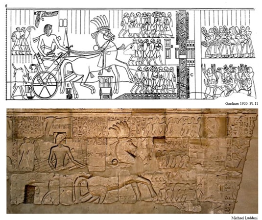 Relief depicting the Horus Way at Tjaru. Egypt’s eastern border is depicted in a relief of Pharaoh Seti I (1291–1279 BC) on the exterior of the Hypostyle Hall’s north wall in the Karnak Temple of Amun in Luxor. Two registers of reliefs contain the only known ancient depiction of the westernmost segment of the famed international coastal highway between Egypt and Gaza. It was called the Horus Way in Egypt and “the road through the Philistine country” in the Bible (Ex 13:17). Pharaoh Seti I is depicted traveling horizontally across the relief in his war chariot. In three scenes the Pharaoh is receiving tribute from dignitaries at Raphia (the final stop on the Horus Way in Canaan), defeating the nomadic Shasu with his bow and finally triumphantly returning from Canaan surrounded by Asiatic captives. Eleven of the 23 known forts on the Horus Way between Egypt and Canaan are depicted in the scenes. The major features along the Horus Way through the desert toward Canaan are forts and accompanying water sources. In the right-hand register seen here, the highway meets a waterway running vertically through the relief. Between monumental structures on the left of the waterway is the name “Tjaru.” This was a large town and important fortress on Egypt’s eastern border, and the staging point for Egyptian military campaigns into Asia. At Tjaru a bridge crosses the waterway and there are additional buildings to the right of the bridge. The vertical waterway is labeled “the dividing waters.” It indicates the Egyptian border as well as the dividing of the green cultivated Nile delta on the east from the brown barren desert to the west. Groups of loyal Egyptian subjects waiting on the other side of the waterway indicate this is Egypt. This suggests the relief should be understood with the Egyptian border running vertically with the waterway, Egypt on the right and the Sinai desert on the left. Treating it like a map, that would put north at the bottom and east to the left. The waterway is depicted with two major features: reeds lining both banks and the water full of crocodiles. At the bottom of the waterway (north) is depicted another larger body of water with fish only (a feature seen by earlier investigators but not visible today). While neither body of water has been identified with any certainty thus far, it does illustrate the reeds of the marshy lake region that gave the sea of the Exodus narrative its name.
Understanding the Horus Way in New Kingdom Egypt offers a tangible explanation for the Biblical statement that the Israelites did not take “the road through Philistine country” (the Horus Way) directly to Gaza on the coast. In taking Egypt’s military road and facing the Egyptian-garrisoned forts along the way, together with the Egyptian army pursuing from behind, it would have been very difficult to not “change their minds and return to Egypt” (Ex 13:17). But this was not God’s plan. Instead, after leaving Pi Hahiroth and crossing the “sea” (the Egyptian border), God told the Israelites to go “by the desert road” (Ex 13:18) toward yam Suph II (Gulf of Suez) rather than into Canaan (Hoffmeier 1996: 181, 187–188). East of the border, the Israelites entered the “Desert of Shur” (Ex 15:22; 1 Sa 15:7; 27:8). Meaning “wall” in Hebrew, “Shur” may have referred to the eastern frontier canal and its accompanying embankments, in conjunction with the line of forts along the border (Scolnic 2004: 102; Hoffmeier 1996: 188). Thus, this desert was immediately on the other side of Egypt’s bordering “wall” of canals, embankments and forts. As this was the desert the Israelites entered immediately after crossing the sea (Ex 15:22), clearly the “desert of Shur” was in the northern Sinai east of the isthmus.
Recent excavations have clearly identified Tjaru, the hieroglyphic name for the important city and military installation on Egypt’s eastern border. From this fort, the Pharaohs of the 18th and 19th Dynasties launched their military campaigns into Asia. Excavations have identified the 18th Dynasty (15th–13th century BC) remains of ancient Tjaru at modern Hebua I, just a few miles northeast of the Ballah Lake (Hoffmeier 1996: 186–187; 2004: 63; 2005: 91–104; Kitchen 2003: 260; Scolnic 2004: 112). This identification has helped scholars begin to place all the other sites prior to the sea crossing in the Exodus itinerary.
Bibliography
Beitzel, Barry J. 1991. The Via Maris in Literary and Cartographic Sources. Biblical Archaeologist 54: 65–75.
Blum, Howard. 1998. The Gold of Exodus. New York: Simon and Schuster.
Franz, Gordon. 2000. Is Mount Sinai in Saudi Arabia? Bible and Spade 13: 101–13.
Gardiner, Alan. 1920. The Ancient Military Road Between Egypt and Palestine. Journal of Egyptian Archaeology 6: 99–116
Hoffmeier, James K. 1997. Israel in Egypt. New York: Oxford University.
———. 2004. The North Sinai Archaeological Project’s Excavations at Tell el-Borg (Sinai): An Example of the “New” Biblical Archaeology? Pp. 53–66 in The Future of Biblical Archaeology, eds. James K. Hoffmeier and Alan Millard. Grand Rapids: Eerdmans.
———. 2005. Ancient Israel in Sinai. New York: Oxford University.
Huddlestun, John R. 1992. Red Sea, Old Testament. Pp. 633–42 in The Anchor Bible Dictionary 5, ed. David N. Freedman. New York: Doubleday.
Kitchen, Kenneth A. 2003. On the Reliability of the Old Testament. Grand Rapids: Eerdmans.
Scolnic, Benjamin E. 2004. A New Working Hypothesis for the Identification of Migdol. Pp. 91–120 in The Future of Biblical Archaeology, eds. James K. Hoffmeier and Alan Millard. Grand Rapids: Eerdmans.
Shea, William H. 1990. Leaving Egypt. Archaeology and Biblical Research 3, no. 4 (Autumn): 98–111.
Wood, Bryant G. 2000. Beneath the Surface: An Editorial Comment. Bible and Spade 13, no. 4 (Fall): 98–99.
———. 2004. The Royal Precinct at Rameses. Bible and Spade 17: 45–51.