This analysis contains extracts from the Study Booklet: The Temple and the Rock.
The Ark of the Covenant was undoubtedly the most holy piece of furniture ever made, if it can be referred to as such. It consisted of a rectangular chest made of shittim wood and covered over with gold. The word Ark, Aron in Hebrew, means merely a chest and has been translated as ‘coffin’ in Gen. 50:26. God had commanded Moses to make the Ark of the Covenant (Ex. 25:10-22) and inside it Moses placed the two tables of the law. Later on, Aaron’s rod that budded was placed in it (Num. 17:10), together with the golden pot that had the manna (Ex. 16:33, Heb. 9:4).
The mercy seat was a kind of lid which closed the chest from above. It was made of pure gold and was held in place by a golden ridge or crown. Beaten out of this mercy seat were two cherubim, which with their wings overshadowed the mercy seat. They were beaten out of the same piece of pure gold as the mercy seat.
The Ark was made in Sinai by Bezaleel ben Uri, whose name appropriately means, “In the Shadow of El (God), the Son of my Light.” After a long journey it was placed eventually in the Holy of Holies of Solomon’s Temple. It was this former location of the Ark of the Covenant which I believe to have found.
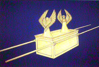 A representation of the Ark of the Covenant
So many researchers have proposed different locations for the Temple and/or for the Ark of the Covenant without having followed a suitable methodology to substantiate their conclusions. This researcher believes that the location of the Temple can only be found when the historical and archaeological development of the present-day Temple Mount has first been analysed. It is always best to begin with the known elements, which in this case are the outer walls of the Temple Mount. Relying on the archaeological data and the information contained in the historical sources, the research then began looking at remains within the Temple area itself.
After having established the location of the pre-Herodian square Temple Mount, the historical sources, notably the Mishnah, led us to look for the location of the Temple on or near es-Sakhra, the rocky mountain top which is visible inside the Dome of the Rock. This rock has never been properly examined and so the analysis of this prime piece of archaeological evidence had to be carried out. Not only were the negative impressions of the Temple walls discovered, but also the former location of the Ark of the Covenant. As the measurements given in Middot were found to be very accurate, the location of the Temple Courts and the Altar could also be accurately calculated.
But let us begin at the beginning and briefly go over the stages of the research which led to our latest conclusions.
The 500 Cubit Square Temple Mount
The two descriptions of the Temple Mount, one by Josephus and the other in the Mishnaic tractate Middot appear to contradict each other. According to Josephus, the Solomonic Temple Mount was a square “having a circumference of four stades, each side taking up the length of a stade” (Ant. 15.400). After Herod had enlarged the Temple Mount, the circumference measured six stadia (War 5.192). Middot 2.1 states that “the Temple Mount (Har habbayit) measured five hundred cubits by five hundred cubits.”
The problem with this statement is that Middot was written after the Roman destruction of 70 A.D., i.e. after the destruction of Herod’s Temple Mount. We know from archaeology that the Temple Mount is not now square in shape, but rather oblong. Both records agree, however, that the Temple Mount was square at one stage of its development. Other discrepancies in the texts complicate matters further. Middot for example, records only one gate in the western wall, while Josephus describes four gates. In the Western Wall of the Temple Mount, four gates have indeed been found, and therefore it has been assumed up until now that the description by Josephus is more reliable than that of Middot.
However, a solution to this problem has been provided by my research, which has located the original 500 cubit square Har habbayit, as described in Middot. It appears that the two sources actually do not contradict, but rather complement each other. It also became clear that only the pre-Herodian square Temple Mount was considered worthy of the title of Har habbayit in Middot, while Herod’s addition was grandly ignored. Josephus acknowledges that the Temple Mount was once square, although his measurement of one stadium (365 cubits) falls short of the Mishnaic 500 cubits, which has proved to be the correct measurement. In short, Josephus concentrates on the Herodian Temple Mount, although he knew that the pre-Herodian Temple Mount was square, while Middot concentrates on the smaller square Temple Mount, as only this part was considered holy.
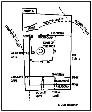 Plan showing the archaeological evidence for the location of the 500 cubit square Temple Mount.
The Step
The starting point of the research was the odd angle of the step at the north-west corner of the raised Moslem platform. Eight flight of steps topped by arcades lead up to the platform of the Dome of the Rock. The steps near the Qubbat el-Khadr are the only ones not built parallel to the walls of the platform, their direction being derived from the angle of the bottom step. This step is made up of a line of single ashlars, in contrast to the other steps of this flight, which are made up of many smaller stones. It appears therefore that this step, which is virtually parallel to the eastern wall of the Temple Mount, is, in effect, the remains of an early wall. The central part of the eastern wall near the Golden Gate, as will be seen below, also contains masonry which pre-dates the Herodian period. As the style of masonry used in this step/wall resembles that found in the central section of the eastern wall, we have therefore identified it as the western wall of the pre-Herodian Temple Mount.
Fosse
In order to determine how far north the original western wall extended, we turn to the records of Warren, who describes an “excavated ditch,” which he found 52 feet (15.85 m.) north of this stairway. Strabo, the Greek geographer and historian, describes this moat or “fosse” and gives its measurements as 60 feet (18.30 m.) deep and 250 feet (76.20 m.) broad. From a defensive point of view, the importance of the fosse is obvious, as it completes the natural boundary to the north of the pre-Herodian Temple Mount, linking the Tyropoeon Valley on the west with the Bethesda Valley, which is a branch of St. Anne’s Valley, flowing eastward into the Kedron Valley. The approach to the Temple Mount from the north was thus effectively cut off.
The same fosse, together with the Bethesda Valley, is recorded by Josephus as having been filled in by Pompey’s soldiers in 63 B.C., thereby enabling them to storm the defensive towers built at the north-western corner of the square Temple Mount. These towers stood apparently in the space of 52 feet between the stairway and the fosse. The western step/wall could therefore not have continued far in a northerly direction.
Northern Rockscarp
Turning to the east, we noticed in the records of Warren that he found along the northern wall of the raised platform, in Cistern 29, the remains of a quarried rockscarp. Further remains of this scarp can be seen near the north-east corner of this platform. Continuing the line of the northern rockscarp westwards and eastwards, we find the northern wall of the square platform. The northernmost stone of the step actually fits exactly in the right-angled corner with the northern wall.
Continuing the line of the rockscarp eastward, we find the north-east corner of the pre-Herodian Temple Mount at the point where it meets the eastern wall, just north of the Golden Gate, at 1,101 feet (335.60 m.) north of the Herodian south-east corner. Some 38 feet (11.60 m.) to the north of this north-east corner of the square Temple Mount, an offset can be seen, which probably was part of a projecting tower.
500 Cubits
The length of the northern wall, measured between the step and the eastern wall, is 861 feet (262.50 m.) This distance turns out to be exactly 500 cubits according to the Royal Cubit of 20.67 inches (0.525 m.). Many tombs around Jerusalem have been cut in the rock, using the length of this cubit as the unit of measurement. This cubit originated in Egypt and is recorded in the Hebrew Bible as “the cubit of the first measure” (2 Chron. 3:3). It is the same measurement as the “cubit and a handbreadth” of Ezekiel 40:5, which shows that a smaller cubit was in use also.
Bend
From the south-east corner of the present-day Temple Mount, the eastern wall shows Herodian masonry for some 106 feet. At that point a seam, or straight joint, is visible, to the north of which Hasmonean masonry appears. Warren noted that 240 feet (73.40 m.) north of the south-east corner, the eastern wall changes its direction slightly. Standing at this corner and looking northwards, this change can be seen with the naked eye. This bend is located at the point where a pillar sticks out from the wall, which is known as Mohammed’s Pillar. As this bend is located exactly 861 feet or 500 cubits south of the projected north-east corner of the square Temple Mount, it provides archaeological evidence for the existence of the south-east corner of the square platform, which is probably preserved deep below ground.
Southern Wall
The southern wall of the square Temple Mount should be parallel to its northern wall. The intersection of the southern wall with the southern continuation of the line of the step would form the south-west corner of the square Temple Mount.
Further support for the location of the southern boundary of the early square Temple Mount can be obtained from the location of the Akra (see pp. 19-20) and the Herodian underground passageways of the Double, Triple and Barclay’s Gates.
The southern passageways are approximately 240 feet (73 m.) long and terminate at the line of the proposed early southern wall. They thus reflect in their length the size of the southern extension of the square Temple Mount.
The underground passage of Barclay’s Gate is L-shaped. The reason for this is, that Herod’s builders built the southern part of the stairway alongside the later Hasmonean extension of the earlier western wall, instead of piercing through it. The distance from the turn of the passageway to the eastern wall is 500 cubits, which again confirms our location of the 500 cubit square Temple Mount.
Hezekiah’s Square Temple Mount
It is not easy to determine when the square Temple Mount was first built. In the light of Josephus’ record in War 5.184,185, it does not seem likely that Solomon is the originator of this square platform, “though the Temple, as I said, was seated on a strong hill, the level area on its summit barely sufficed for shrine and altar, the ground around it being precipitous and steep. But King Solomon, the actual founder of the Temple, having walled up the eastern side, a single portico was reared on this made ground; on its other sides the sanctuary remained exposed. In course of ages, however, through the constant additions of the people to the embankment, the hill-top by this process of levelling up was widened.” It was therefore some time after King Solomon had built the Temple that an artificial mount, the Temple Mount, was created round the sanctuary.
The first time the phrase “Temple Mount” or more precisely “Har Bayit-YHWH” – “The Mount of the House of Yahweh” is used in Scripture is during the reign of Manasseh (2 Chron. 33:15). As it seems unlikely that Manasseh did anything good for the Temple of Jerusalem, but rather against it, it is reasonable to suggest that it was his father Hezekiah, the great builder, who actually constructed a square artificial mount around the original Temple of Solomon. Previously, Solomon’s Palace and the House of the Forest of Lebanon stood to the immediate south of the Temple, but, as there is no reference to the destruction of these buildings in the Biblical account of the destruction of Jerusalem by the Babylonians, they were probably dismantled earlier by Hezekiah in order to build “The Mount of the House of Yahweh.” In Isa. 22:8-11, the prophet describes the building activities of Hezekiah, i.e. the Pool of Siloam (vs. 9) and the Broad Wall (vs. 10). The evidence for the removal of Solomon’s Palace and the House of the Forest of Lebanon may be found in vs. 8, “thou didst look in that day to the armour of the house of the forest.” This therefore seems to further indicate that the square Temple Mount was constructed before the fall of Jerusalem in 586 B.C. and more precisely during the reign of King Hezekiah.
Comparing the two accounts of the building of the Temple, the first in 1 Kings chapters 6 and 7, and the second in 2 Chron. chapters 3 and 4, many differences become apparent. In the first description, the pillars of brass were 18 cubits in height, while the second records them as 35 cubits high. The height of the first Porch is not given; the second one was 120 cubits high. As the porch was probably made in proportion to the pillars before them, one can assume that the first porch was lower than the second. In the first account the Temple was surrounded by three storeys of chambers; in the second account these chambers have been replaced by upper chambers. The first laver had knops under the rim; the second had two rows of oxen. The first contained 2000 baths; the second 3000. From all this we must conclude that the Temple which was destroyed by the Babylonians, was not the same building which was constructed by Solomon. During the First Temple period, which lasted more than 400 years, the Temple had apparently undergone many changes and repairs. This is the reason then for the two different descriptions. Solomon’s Temple obviously had suffered so much from neglect, wanton destruction and earthquakes, that King Hezekiah had it completely renewed and made a 500 cubit square artificial mount around it in order to restore its glory. It was this Temple that was destroyed by the Babylonians. However, despite all the changes and rebuilding, this last Temple is still referred to as the First Temple. The one built after the Babylonian exile was called the Second Temple.
The Location of Solomon’s Temple
Although some researchers would place the Temple elsewhere, Josephus clearly states that Solomon built the Temple on the top of the mountain. The Sakhra inside the Dome of the Rock is indeed the top of the Temple Mount and to place the Temple in a different and therefore lower place would contradict this historical record.
The problem with the Sakhra is that some scholars make it the place where the Altar of Burnt Sacrifices stood, while others, including myself, locate the Holy of Holies over the Rock. An additional, although related, problem is Araunah’s threshing floor, which some say was located on the Sakhra.
There are several objections to putting the Altar over the Rock. First of all, the Mishnah (Middot 3.4) says that the Altar was made of whole stones, “taken from the valley of Beth Kerem” (a few miles away from the Temple), and not of natural rock. The proponents of the ‘Sakhra = Altar’ theory say that the cave below served to drain away the blood, but recent observations have established that this cave has no outlet and therefore could not have fulfilled this function. Also, the Altar, which measured 55 feet square, was larger than the Rock, whose dimensions are 43 by 56 feet. It would therefore make both Rock and cave disappear below its construction, making it impossible for the blood to drain away. Finally, in Jewish understanding, the higher the ground level, the holier the location. This would indicate that the Holy of Holies would have occupied the highest place on the mountain as most Orthodox Jews indeed believe.
 The Location of the Holy of Holies and the Ark of the Covenant on the Sakhra
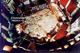
The problem with locating the Holy of Holies over the Sakhra is that the Sakhra is larger than the Holy of Holies. A solution to this problem would be if at least one of the walls of the Holy of Holies were built over the Rock. Indeed, in the summer of ’94, the research I was engaged in led to the discovery of the foundation trench of the southern wall of the Holy of Holies. Certain areas on the Rock, to the west of the opening in the ceiling of the cave, are flat receptacles for rectangular ashlars. Two are clearly visible and there are some other areas to the south of these, just before the rock slopes down steeply to the south. When viewed from the east, looking west over the opening, the two flat areas look like a channel cut across the Sakhra from east to west. The total width of all these areas is about 10 feet which corresponds, according to the cubit of 20’8” which was used in the building of the Temple, with 6 cubits – the width of the original Temple wall.
The distance between this foundation trench and the northernmost rockscarp is exactly 10.50 m. or 20 cubits (see plan illustration above). This rockscarp then, which continues below the floor for another meter, was the place of the northern wall of the Holy of Holies.
The western wall would have stood at the foot of the natural western scarp. As the direction of the scarp is virtually identical to that of the step and of the eastern wall of the Temple Mount, the Temples of both the First and Second Temple periods would have had the same orientation, i.e. the longitudinal axis of the Temple would have been at right angles to the eastern wall. As the western scarp is a natural one and therefore never changed its direction, there are no grounds to believe that the axis of the First Temple would have been different to that of the Second Temple period. The continuation of this axis, which is at right angles to the eastern wall of the Temple Mount, is aligned with the top of the Mount of Olives, where the Red Heifer was sacrificed (see Fig. 3). According to Middot 2.4, “the [High] Priest, that burns the [Red] Heifer and stands on the top of the Mount of Olives should be able to look directly into the entrance of the Sanctuary when the blood is sprinkled.” This then is another confirmation of our location and orientation of the Temple.
There never was a stone wall between the Holy of Holies (Kodesh haKodashim or Dvir) and the Holy (also called Heichal) and therefore no signs of such a partition would have been visible on the sloping surface in the east of the Sakhra. In Solomon’s Temple there was a wooden partition and in the Second Temple a veil separating the two chambers. After I had set out on plan this dividing line, together with the location of the Holy of Holies, I was struck by the location of a depression right in the middle of this square.
The Former Location of the Ark of the Covenant in Solomon’s Temple
The last time the Ark of the Covenant is mentioned in Scripture was when King Josiah (in 623 B.C.) ordered the Ark to be put back in the Temple (2 Chron. 35:3). From this we understand that during the reign of wicked kings, the priests would have taken the Ark out of the Temple and hidden it away somewhere. There is no further mention of the Ark in the Biblical record after this, but it does not seem likely that the Ark was destroyed by the Babylonians in 586 B.C., as such a calamity would certainly have been mentioned. When the Second Temple was rebuilt in the time of Ezra, the Ark was not returned to the Temple. The Holy of Holies presumably remained empty until the destruction of Herod’s Temple in 70 A.D. Indeed, according to Josephus, the inner chamber of the Temple was completely empty, “In this stood nothing whatever: unapproachable, inviolable, invisible to all, it was called the Holy of Holy” (War 5.219). He was apparently unaware of the existence of this most interesting feature. According to my plan, it falls exactly in the centre of the Holy of Holies. The dimensions of this level basin agree with those of the Ark of the Covenant which were 1.5 x 2.5 cubits (2’7″ x 4’4″ or 79 cm. x 131 cm.), with the longitudinal axis coinciding with that of the Temple. Its location is rather unique, as it could only have been the place where the Ark of the Covenant once stood. It appears to me therefore that during the First Temple period, an emplacement was prepared for the Ark by cutting this flat basin in the rock, for it is clear that without such a flat area, the Ark would have wobbled about in a most undignified manner, which would have been inconceivable.
Several texts in 1 Kings 6 and 8 may actually refer to a specially prepared place for the Ark. In 1 Kings 6:19 it says that Solomon prepared the Oracle (Dvir) in the midst of the house from within “to place there the Ark of the Covenant of Yahweh” and in 1 Kings 8:6, “the priests brought in the Ark of the Covenant of Yahweh unto his (or its) place, into the Dvir of the house, to the most holy (Kodesh haKodashim), under the wings of the Cherubim.” This means that a special place was prepared or assigned to the Ark. This is further emphasised in vss. 20,21 of the same chapter, where Solomon says that he has “built an house for the name of Yahweh God of Israel. And I have set there a place for the Ark…” The Hebrew verb “seem” (sin-yod-mem) which is translated here as ‘set’, can also mean ‘put’ or ‘make.’ In the light of this discovery, I suggest to translate this verse as “I have made there a place for the Ark.”
This small basin which Solomon had made has been preserved up to today. Of course, its orientation mystified me at first, as most representations show the Ark standing in the Tabernacle or in the Temple with its longer side facing the partition, while now it is clear that it was the shorter side that was first seen by the High Priest when he entered the Holy of Holies. Contemplating this, it became obvious that this was, of course, the only way it could have stood, as otherwise the priests would not have been able to take out the staves (1 Kings 8:8). This would have been impossible regarding the position of the two large cherubim under whose wings the Ark was placed, and also, as the staves were supposed to be 10 cubits long according to the Talmud Yoma 54a, they would have hit, on their removal, the walls of the Holy of Holies, which was only 20 cubits square. Sometimes the staves are represented as having been fixed along the two shorter sides of the Ark. Not only is this an unnatural way of carrying long objects, but also it would be impossible to place the Ark in its receptacle, as the staves would have touched the two large cherubim first.
In the Temple of Solomon and in the later reconstructions, the eastern slope would have served as a ramp for the High Priest to ascend once a year, on the Day of Atonement (Yom Kippur), to the Holy of Holies. Later, Herod created a six cubit high foundation for his Temple, which almost completely buried the Rock. This would agree with Yoma 5.2: “After the Ark was taken away a stone remained there from the time of the early Prophets, and it was called ‘Shetiyah’. It was higher than the ground by three finger breadths. On this he used to put [the fire-pan].” From this record it appears that only the very top of the Sakhra remained visible inside the Holy of Holies. Instead of the ramp inside the Solomonic Temple, the Herodian Temple floor was reached by a 12 stepped staircase, which was located outside the Temple, in front of the Porch. The new floor was apparently a little (three finger breadths) lower than the top of the Sakhra which was the floor of the Holy of Holies.
We believe that during the Second Temple period, the High Priest on Yom Kippur placed his censer or fire-pan in this depression, which was the same place where, during the First Temple period, the Ark of the Covenant stood.
Araunah’s Threshing Floor and the Location of the Altar
Another Biblical description had to fit in with the location of the Holy of Holies on the Sakhra and that is the location of the Altar and the connection with the threshing floor of Araunah. The location of the First Temple is, of course, closely related to the threshing floor of Araunah, the Jebusite King, of whom David bought it to build an altar to the Yahweh his God (1K. 24. 18-25). It is generally believed to have been built in the same place where Isaac was bound, as related in Gen. 22.
However, we would like to be more precise about the relationship between the Sakhra and the location of Araunah’s threshing floor and the altars erected by Abraham and David and the place of Solomon’s Temple. First of all therefore we have to examine the historical information as preserved in the Hebrew Bible.
It is interesting to note that in both cases Abraham and David were shown the place where they were to build the altar by divine instruction. Abraham was sent to the land of Moriah to “offer him [Isaac] there for a burnt offering upon one of the mountains which I will tell thee of” (Gen. 22:2). After Abraham was withheld by the angel from sacrificing Isaac, he called the name of the place “YHWH yiraeh” as it is said this day “beHar YHWH yiraeh.” This latter phrase can be translated “in the mountain Yahweh will provide,” or “in the mountain the Yahweh shall be seen.” Both translations have, of course, a prophetic impact. But where was the exact spot where Abraham built the altar? We are not told in Genesis, but the prophetic meaning of the words of Abraham would indicate the establishment of a continuous sanctity of this place as an altar.
Next we read about events which occurred towards the end of David’s life and which are recorded in 2 Sam. 24 and 1 Chron. 21. God was going to punish Israel, because David had ordered Joab to count Israel and Judah, apparently having forgotten the injunction recorded in Ex. 30:12 to make provision for paying a ransom per head. When an angel was sent by God to bring a pestilence upon Israel, he was stopped when he stretched out his hand over Jerusalem (2 Sam. 24:15,16). It is instructive to note where David saw the angel “And the angel of the Yahweh stood by the threshing floor of Ornan [Araunah] the Jebusite. And David having lifted up his eyes, and saw the angel of the Yahweh stand between the earth and the heaven, having a drawn sword in his hand stretched out over Jerusalem” (1 Chron. 21:15,16).
Two things should be noted here, first of all that the angel did not stand on the threshing floor, but beside it (etsel in Hebrew), and secondly that the angel must have stood on higher ground. Now, threshing floors are not usually located on the top of a mountain but a little below it, so that the wind will carry away the chaff only and not the grains as well. The prevailing wind in Israel is from the west, so that we would expect Araunah’s threshing floor to be located below and to the east of the Sakhra.
The position of the angel, beside the floor, is called “between the earth and the heaven.” He was standing evidently higher than David, so that it seems most likely that the angel stood on top of the Sakhra, as it were between heaven and earth, as he also had direct communication with God in heaven, although he was standing on the ground.
David subsequently bought the threshing floor from Araunah. He paid first 50 silver shekels for the threshing floor (2 Sam. 24:24) and later 600 shekels of gold for the whole mountain (1 Chron. 21:25), establishing his ownership of the Temple Mount. He then built an altar, not on top of the mountain, where the angel stood, i.e. the Sakhra, but on the threshing floor, which was lower down (2 Sam. 24:24,25), in a location which is now 20 feet east of the Dome of the Chain.
From the text then, it is therefore obvious that the Sakhra could not have been the place of the Altar. The Sakhra would also have been too small for a threshing floor as the oxen would be in continuous danger of falling over the steep edge. An additional difficulty would be that if the Temple was built to the west of the Sakhra it would have needed very deep foundations, much deeper than the 6 cubits mentioned, as the rock there slopes away quite rapidly.
There is further historical evidence in the Scriptures showing that the Holy of Holies was located in the highest point of the Temple. In Isa. 6,1 the prophet sees a vision of the Lord sitting in the Temple, “high and lifted up.” The place reserved for the Deity was undoubtedly the Holy of Holies, where only the High Priest once a year was allowed to enter on Yom Kippur (Lev. 16:29,30), i.e. on the tenth day of the seventh month. The vision, which is also referred to in John 12:41, occurred during the year that King Uzziah died, presumably of the leprosy which he contracted when offering incense in the Temple, which he was not allowed to do (2 Chron. 26:16-21). It appears therefore that the Holy of Holies was higher than any other part of the Temple. The angel, which David saw, was therefore standing in the place which later became the Holy of Holies, possibly on the very spot where the Ark was later placed in the centre of the inner chamber. After all, that was the oracle of God from where he spoke, “And when Moses was gone into the tabernacle of the congregation to speak with him, then he heard the voice of one speaking unto him from off the mercy seat that was upon the ark of the testimony, from between the two cherubim: and he spake unto him” (Num. 7:89).
The Ark and the Future
To have found the former location of the Ark of the Covenant, so wonderfully preserved, was a totally unexpected conclusion to my 22 years of research on the Temple Mount. In recent years there has been a surge of interest in finding the actual Ark of the Covenant. According to the Book of Maccabees, Jeremiah hid the Ark on Mount Nebo in Jordan. A recent theory places the Ark in Ethiopia, while many rabbis believe that it is still hidden somewhere under the Temple Mount. This belief is mainly based on 1 Kings 8:8 “and they drew out the staves, that the end of the staves were seen out in the holy before the oracle, and they were not seen without: and they are there unto this day.” “Unto this day” are supposed to be the key words which indicate that the Ark is still hidden today somewhere under the Temple Mount. A few years ago a group of rabbis did some illegal digging under the Temple Mount, which, not surprisingly caused considerable disturbance among the local Arab population.
Despite all the claims and expectations, however, nobody knows where the Ark of the Covenant actually is. Recently, while rereading the account in Numbers 3 concerning the responsibilities of the various Levitical families vis-a-vis the Tabernacle, we noticed in verse 30 of this chapter, that the name of the chief of the Kohathites, who was the first person to have the charge of the Ark of the Covenant, was called Elizaphan ben Uzziel. His name means “My God (El) has hidden” and he was the son of “My Strength is El.” It is a comforting thought that if the Ark still exists and has a future role to play, then it must have been hidden with the knowledge of God himself and that it will be found only when it is in His purpose.
This article has been republished with permission. For more information regarding the ministry of Leen and Kathleen Ritmeyer, visit Ritmeyer Archaeological Design at www.ritmeyer.com.